
Transportation
We Take You in the Right Direction
NV5 Geospatial provides comprehensive geospatial solutions tailored for transportation infrastructure. Our transportation GIS services expertise spans roadways, airports, and rail systems, employing advanced technologies like lidar for transportation, mobile mapping, and hyperspectral imaging to deliver precise and actionable data. We integrate linear reference Systems (LRS) and asset conflation techniques to enhance data accuracy and utility.
Customized Approach
We work with our transportation clients to select the appropriate platform, methodology, and analytics to maximize the value of our services. From aircraft to drones, or ground-based mobile platforms, we continue to push ourselves to better serve our clients. Our Department of Transportation experience and transportation consulting expertise is unparalleled. So when you’re ready to ask, we’re ready to get moving.
Quality Data
We excel in all manners of spatial data collection, analysis, and visualization.
• Lidar: Aerial | Mobile | UAV
• Thermal Imaging
• Orthophotography
• Planimetric Mapping
• Topographic Mapping
• GIS Features & Attribution
Actionable Deliverables
We bring the data to life and deliver the information you need to make decisions and take action.
• Digital Twins
• Asset Management
• Bridge Inspection
• Corridor Mapping
• Engineering Design
• Environmental/Hazard Mapping
• Emergency Response

NV5 has held the Esri Platinum Partner status in the Esri Partner Network since 2010 and maintains seven Esri specialty designations, NV5’s staff are experienced and maintain key certifications across the Esri environment.
Planning
Engineering
Thermography for Bridge Decks
Transport Clearance Analysis
Documentation
During construction – Track construction progress with a variety of our services such as periodic HD video, Orthophotography or Lidar. Conducted on a regular schedule, this monitors project status, analyzes problem areas and documents the completion of milestones for stakeholders and the public.
After construction – Create maps and 3D models of the as-built environment for reference files, GIS databases, or to help launch future engineering work. Imagery can be used for orthophotography and planimetric mapping while Lidar can be used for a variety of applications such as mapping final surface elevations and gradients, and extracting cross-section data sets. Mobile mapping systems can drive down the completed right-of-way and capture as-builts for the record.
ENTERPRISE GIS APPLICATIONS
NV5 Geospatial develops geospatial solutions to solve complex challenges for DOT & Engineering solutions.
· Software Design & Implementation
· Workflow Development & Automation
· Data Management
· Cloud Services, Hybrid or On-Prem
· IT Governance
· AI / ML

Application Solutions
NV5 Geospatial offers a comprehensive selection of software services and products designed to transform data into meaningful information that allows resource and asset managers to take action.
By providing premium enterprise-level GIS products, custom-designed applications, and GIS consulting services, our software team optimizes decision making while maximizes geospatial data investment for our clients
- Enterprise GIS Systems and Applications
- Systems and Data Migrations
- Cloud hosted or On premise
- Maintenance, Management, and Support
- Extensions and Custom Applications
- Automation
ESRI Partnership
In addition to custom applications, we are one of seventeen companies certified platinum as an ESRI partner.
READ OUR TRANSPORTATION BROCHURE
Transportation Brochure
NV5 Geospatial has been trusted to provide on-target geospatial solutions for roadways, airports, and all modes of rail infrastructure for decades. Our clients trust us because we’ve proven time and time again that we can find a better way to ensure the right solutions for their specific needs. In each case, we work with our transportation clients to select the appropriate platform, methodology, and analytics to maximize the value of our transportation GIS services
Planning
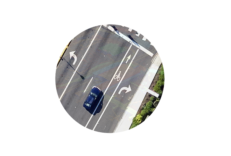
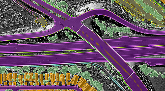
Coordinate the preliminary stages of a project including traffic studies, feasibility assessments, and an evaluation of potential environmental impacts for route alternatives. Planners, environmental scientists and engineers depend on our data and expertise to make decisions for corridor studies, route realignments, and road and bridge improvements. NV5 Geospatial has extensive experience supporting light rail, high speed rail, and interstate rail infrastructure as well as environmental assessments. Our services support the assessment and characterization of environmental conditions required for permitting applications. Solutions range from the provision of multispectral, hyperspectral, thermal, and lidar datasets, to traditional aerial photography, mapping and orthophotography.
Engineering
NV5 transportation GIS services consist large-scale mapping solutions, including low level/high accuracy lidar and low altitude photogrammetric mapping. From this data, NV5 Geospatial provides dense elevation point clouds, TINs, and mapping depicting closely spaced contours and detailed existing conditions. Mobile mapping can also be used to capture existing road, slope, ramp, and bridge abutment conditions. In addition, our high resolution orthophotography is considered by many engineers to be an indispensable design tool. With NV5 Geospatial in support, design teams are able to develop their construction documents with confidence.
Thermography for Bridge Decks
Thermal imaging identifies otherwise undetectable structural problems well before they reach the surface of bridge decks, and long before they can be seen during close range visual inspections.
Transport Clearance Analysis
NV5 Geospatial uses lidar to perform three-dimensional swept path clearance analysis for roads, bridges, tunnels, and other transportation infrastructure elements. Analysis is performed to determine if the oversize freight will be able to navigate a proposed route without conflict. These types of analysis are performed to validate as-built dimensions and support the Department of Transportation who assess routes using two dimensional drawings and cross sections.
Documentation
During construction – Track construction progress with a variety of our services such as periodic HD video, Orthophotography or Lidar. Conducted on a regular schedule, this monitors project status, analyzes problem areas and documents the completion of milestones for stakeholders and the public.
After construction – Create maps and 3D models of the as-built environment for reference files, GIS databases, or to help launch future engineering work. Imagery can be used for orthophotography and planimetric mapping while Lidar can be used for a variety of applications such as mapping final surface elevations and gradients, and extracting cross-section data sets. Mobile mapping systems can drive down the completed right-of-way and capture as-builts for the record.
eGIS
NV5 Geospatial’s GIS services offer a high degree of user functionality to help our clients manage their transportation corridors. These services include system analyses, development, design and updating. Components can include data capture and conversion, geodatabase modeling, document imaging and archiving solutions. On a recent project we created a project catalog system that provided single-click access to every dataset acquired during the project, giving the client management of all documentation from start to finish. Learn more about our eGIS capabilities.