From Data Acquisition & Advanced Analytics to Action
Our geospatial solutions identity threats to your system and quantify the level of risk, so you can take the most effective actions to mitigate any potential issues across your utility network.
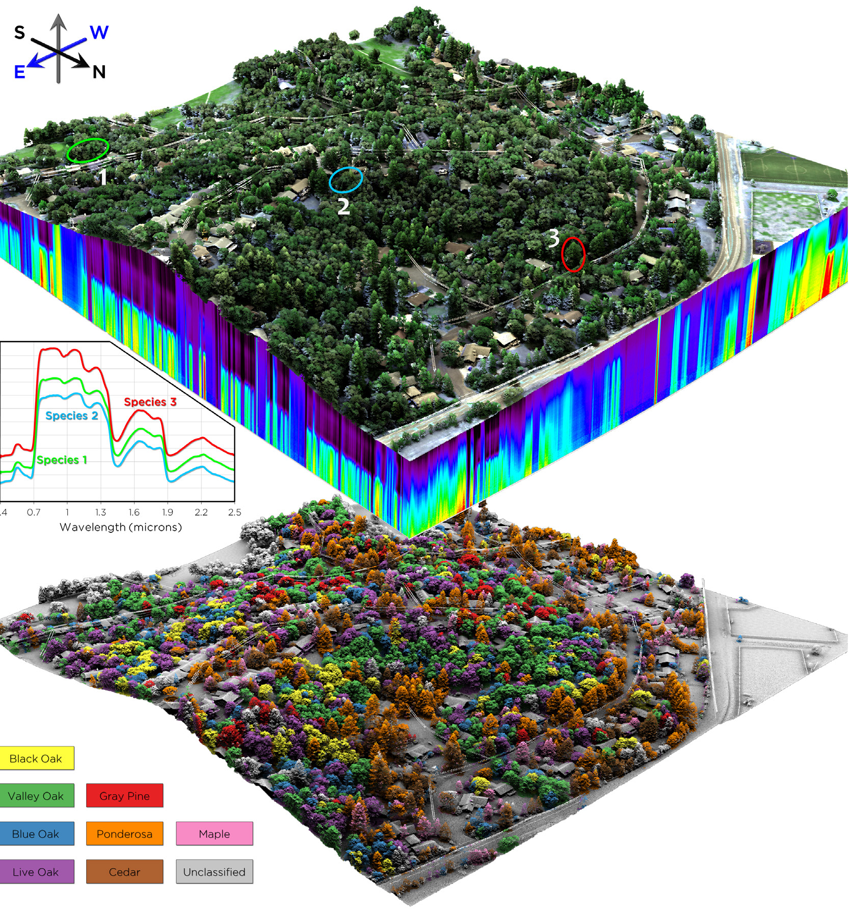
VEGETATION MANAGEMENT
Rapid Reporting
Time matters when it comes to vegetation risk remediation; our Rapid Reporting analysis delivers results in mere weeks after data collection, identifying Fall-in and Grow-in risks on as-flown conditions. Furthermore, we provide quick-turnaround assessments on modeled conditions.
Trim Work Optimization
NV5’s Trim Optimization builds a tailor-made risk profile of vegetation on your system by combining lidar proximity analysis with other factors such as tree health, ground slope, tree lean, overhang, and volumetrics.
The results provide defensible metrics to prioritize work while reducing costs and improving system safety and reliability.
Fire Mitigation
Realize an effective wildfire mitigation plan by incorporating geospatial analysis to determine fire risk factors: tree health, overstrike potential, fuel load quantification (IVM), defensible space encroachments, and work prioritization.
ASSET MANAGEMENT
Distribution Pole Management
Joint Use: We utilize geospatial data to generate a comprehensive inventory of utility pole assets and determine pole capacity.
NESC: We assess your network for risk and identify specific measurements on poles to maintain regulatory compliance.
Pole Loading: We ensure safe load conditions through the integration of remote sensing data with pole loading software.
T-Line Modeling
Better manage operations and quickly respond to reliability issues with an accurate, multi-dimensional view of all utility assets, roads, buildings, and vegetation in transmission corridors. Our solutions include engineering-grade as-builts, sag and sway analysis, access road delineation, asset inventories, and ROW encroachment analysis.
Substation Mapping & Security
We offer a variety of real-time monitoring and change detection services. 3D modeling and monitoring provides substation engineers with high-accuracy as-builts to support maintenance, expansions, security planning and connectivity to renewable energy and electric transmission infrastructure. Additionally, we deploy tailored security systems to identify and alert on physical threats.
T-Line Siting Analysis
Accurately Identify, Evaluate and Execute Line Site Routing with GeopsatialIntelligence. As co-developer of the EPRI-GTC Overhead Transmission Line Siting.
Methodology, NV5 has an unmatched expertise in helping electric utilities locate preferred routes for new transmission lines and deliver safe & reliable electric service.
- Rigorous Approach
- Industry-leading Siting Methodology
- Faster, Defensible Decisions
Esri Utility Network
Strengthen network visibility, support grid modernization, and enable real-timedecision-making with ArcGIS Utility Network. As an Esri platinum-partner we’re experts in:
- UN Migration and Implementation
- Data Readiness & Cleanup
- Business System Integration EAM, billing, modeling, Trimble, etc.
- Architecture Review, Design & Upgrades
- Cloud Migration & Managed Services
- VertiGIS Implementation & Deployments
ENVI Discover
After working with many utilities that were struggling to access and interpret information from their vast quantities of disparate data, NV5 developed ENVI Discover. This scalable web platform centralizes all your data in one intuitive interface, so your entire team – from analysts to executives – can instantly access, visualize, and analyze critical information.
Schedule a Meeting
Let’s find a solution that meets your mission requirements. Contact us. Let’s get started today!
Electric Utilities
Fusing Data on Doomed Ash Trees
INSITE is a scalable agnostic platform designed to provide a single source of truth for your entire organization.
Discover the Power of INSITE
NV5 Geospatial is at the forefront of using geospatial analytics to help utilities deliver safe and reliable electric service. We have more than two decades of experience providing industry-leading geospatial services. We serve dozens of utilities providers across North America.
Vegetation Management
Save time and money by identifying clearance hazards without a site visit and make more informed decisions about when and where to deploy clearing crews. Our best in class utility vegetation management solutions include clearance detection analytics, minimum ground to conductor clearances, hazard tree detection, ROW tree inventory, change detection, and our INSITE web platform.
Vegetation Management - Rapid Reporting
Remote sensing improves accuracy, reduces turnaround time on new data acquisition, and provides opportunities for business growth. NV5 Geospatial is the best in the business with remote sensing data and data analysis.
Prune Optimization
Identifying risk is essential to set priorities for vegetation management. A proactive approach assesses future as well as present risk. This approach also improves outcomes while maximizing operational efficiency.
Prune Optimization is predictive modeling analysis for vegetation management. This method uses existing lidar and historical data to identify the relative level of asset risk from trees by quantifying the potential for causing asset damage.
To learn more, view our recorded webinar presented by Will Fellers, Team Lead Data Scientist, and Sam Johnson, Product Delivery Manager.
Distribution Asset & Vegetation Management
NV5 Geospatial is leading the way with asset management solutions for joint use, NESC clearances, and pole load analysis as well as vegetation management specifically designed for distribution networks.
Substation Mapping
3D modeling provides substation engineers with high accuracy as-builts to support substation expansions, security planning and connectivity to renewable energy and electric transmission infrastructure.
Transmission Line Modeling
Better manage operations and quickly respond to reliability issues with an accurate, multi-dimensional view of all utility assets, roads, buildings, and vegetation in transmission corridors. Our solutions include engineering-grade as-builts, automated access road delineation and inventories, and ROW encroachment analysis.
Transmission Line Siting
Plan for growth by identifying suitable routes for new transmission lines. Our experts work with transmission developers and consultants to help implement the widely used EPRI Siting Methodology, which NV5 Geospatial co-developed. Our siting experience includes hundreds of projects in 8 states and 3 countries as our team developed Corridor Analyst Software and sold to Trimble who distributes worldwide.
LANDMIND
As a company you invest great amounts of time, money, and energy into maintaining the health and safety of your assets. NV5 Geospatial recognizes the need to extend that same diligence to managing the safety, health, and wellbeing of your most precious asset, your people. NV5 Geospatial’s LANDMIND ensures your field crews have the best geohazard & vehicle obstruction intelligence available to keep them and your assets safe.
Geologic Hazard Mapping
Identify and mitigate potential geologic hazard threats to electric utility infrastructure utilizing our proprietary terrain failure and fault detection and proximity analysis solutions. Utilizing an automated approach, NV5 Geospatial’s methodology offers an accurate and efficient way to detect areas of failed terrain using high-resolution lidar.
Hydroelectric Dams
Use engineering-grade 3D models to view as-built conditions, comply with FERC requirements, and help ensure the safe operation of hydroelectric dams. Our unique solutions for hydroelectric facilities include hydrologic modeling, dam subsidence monitoring and dam inundation simulation.