Caught in a landslide? Know the realities

In response to the deadly Oso Landslide of 2014, government agencies have been working diligently to update landslide hazard analysis.  Because LiDAR data can map terrain beneath vegetation and tree canopy, it is ideal for revealing potential hazard.

King County has released a new landslide hazard map that utilizes the new technology.

As stated in the Natural Resources and Parks Newsroom,

“Updating these maps with advanced technology makes us better informed and in better position to protect people, property and critical public infrastructure,” said Flood Control District Chair Reagan Dunn. “It will also help us be more strategic in how we work to reduce flood risks.”

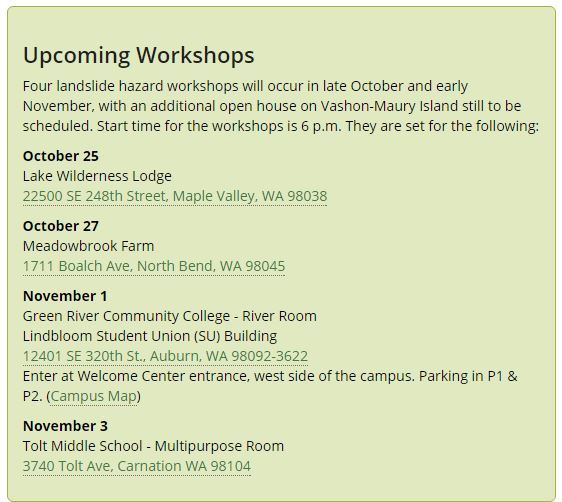
The maps are publicly available online, see links below.  Additionally, the county is conducting four workshops to educate the public on the information contained in the maps and how it can help improve safety and quality of life in a variety of ways.

Quantum Spatial collected the LiDAR imaging via airborne survey and has years of experience with terrain mapping.  Visit our Terrain Analysis page for more details or read past landslide related posts.

LiDAR Dramatically Improves Landslide Assessment, Detection and Mitigation

LiDAR Detects Changes to Oso Mudslide Landscape

Landslide Hazard Map (To view the landslides, turn on the landslide layer using the dropdown controls on the upper-right of the header bar.)

LiDAR Terrain Map

Fill out the form below to download the handbook.

Form #1 - Redirection to PDF

Form #2 - Sends email containing the link to the PDF

"*" indicates required fields

This field is for validation purposes and should be left unchanged.

eNewsletter - NV5 Real Estate Transaction Services

Contact NV5 Real Estate Transaction Services

Download NV5 2022 Compliance Calendar

Please fill out the form below. After successful form submission, you will be redirected to the requested file. Thank you.

"*" indicates required fields

We are an equal opportunity employer. All applicants will be considered for employment without attention to race, color, religion, sex, sexual orientation, gender identity, national origin, veteran or disability status. We ensure nondiscrimination in all programs and activities in accordance with Title VI of the United States Civil Rights Act of 1964. If you need more information or special assistance for persons with disabilities or limited English proficiency, contact MaryJo OBrien at (954) 495-2112. Persons with hearing-and speech-impairments can contact the NV5 by using the Virginia Relay Service, a toll-free telecommunication device for the deaf (TDD). Call 711 for TTY/TDD.
This field is hidden when viewing the form
This field is for validation purposes and should be left unchanged.

Hyperspectral Imaging - Technically Speaking

Our internal innovation and development team constantly analyzes new technology and develops solutions to meet our client’s challenges. Our Technically Speaking series is one way we share our technical findings with the professional community. 

Please tell us a little about yourself by filling out the form below, and we’ll share the document with you, thanks!

Accuracy Part 1- Technically Speaking

Our internal innovation and development team constantly analyzes new technology and develops solutions to meet our client’s challenges. Our Technically Speaking series is one way we share our technical findings with the professional community. 

Please tell us a little about yourself by filling out the form below, and we’ll share the document with you, thanks!

Prune Optimization Webinar Recording

NV5 Geospatial releases a new predictive modeling platform for vegetation management that uses existing lidar and historical data to identify the relative level of asset risk from trees by quantifying the potential for causing asset damage. 

Please tell us a little about yourself by filling out the form below, and we’ll share the document with you, thanks!

Topobathy Lidar - Technically Speaking

Our internal innovation and development team constantly analyzes new technology and develops solutions to meet our client’s challenges. Our Technically Speaking series is one way we share our technical findings with the professional community. 

Please tell us a little about yourself by filling out the form below, and we’ll share the document with you, thanks!

Contact Geospatial

Contact Geospatial