Quantum Spatial Team Recognized for Exceptional Ecological Work with BLM’s Rapid Ecoregional Assessment Program

What is the REA program?

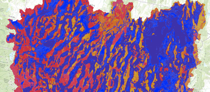
Managed by the BLM, the Rapid Ecoregional Assessment (REA) program integrates varied datasets in order to evaluate ecosystem dynamics, habitat quality, and climate change.  Analysis includes topics ranging from vegetation distribution to hydrology studies to the effects of specific land-use practices. The purpose of the program is to provide meaningful information by utilizing BLM’s extensive database to conduct research, then make the results available so that business, government, and the general public can make informed land-use decisions.

Data, data, data!

The results are compiled into regional reports which include maps, charts, and illustrations. The reports cover a considerable amount of land use issues, and they often include case studies that delve into particular conservation issues such as endangered species vulnerability and the spread of invasive species. Data associated with each report is included on each region’s data download page.

“Certification of Excellence”

Danelle Malget, Laura Van De Riet, and Chris Woodward, members of the Quantum Spatial team, have been recognized by BLM for exhibiting “tireless enthusiasm, dedication, and hard work,” while contributing to the REA effort. They are involved with every aspect of the REA program providing onsite GIS data management, GIS modeling, and scripting support as well as managing several hundred program datasets.

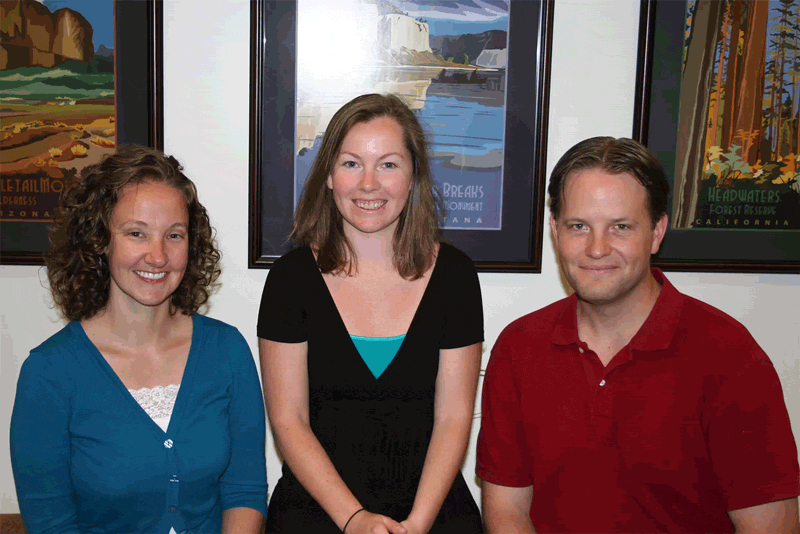
Danelle writes scripting code to streamline the quality control process and facilitates automation of the preparation and publication of the datasets, map services and metadata.

Laura’s contribution includes QA/QCing REA data received by the BLM, preparing REA data for public consumption, and continuously participating in workflow improvement.

Chris works to re-assemble, understand, and document the geospatial models within each REA. He also works with various nationwide BLM resource specialists to train and apply REA products and methods for BLM business practices.

Fill out the form below to download the handbook.

Form #1 - Redirection to PDF

Form #2 - Sends email containing the link to the PDF

"*" indicates required fields

This field is for validation purposes and should be left unchanged.

eNewsletter - NV5 Real Estate Transaction Services

Contact NV5 Real Estate Transaction Services

Download NV5 2022 Compliance Calendar

Please fill out the form below. After successful form submission, you will be redirected to the requested file. Thank you.

"*" indicates required fields

We are an equal opportunity employer. All applicants will be considered for employment without attention to race, color, religion, sex, sexual orientation, gender identity, national origin, veteran or disability status. We ensure nondiscrimination in all programs and activities in accordance with Title VI of the United States Civil Rights Act of 1964. If you need more information or special assistance for persons with disabilities or limited English proficiency, contact MaryJo OBrien at (954) 495-2112. Persons with hearing-and speech-impairments can contact the NV5 by using the Virginia Relay Service, a toll-free telecommunication device for the deaf (TDD). Call 711 for TTY/TDD.
This field is hidden when viewing the form
This field is for validation purposes and should be left unchanged.

Hyperspectral Imaging - Technically Speaking

Our internal innovation and development team constantly analyzes new technology and develops solutions to meet our client’s challenges. Our Technically Speaking series is one way we share our technical findings with the professional community. 

Please tell us a little about yourself by filling out the form below, and we’ll share the document with you, thanks!

Accuracy Part 1- Technically Speaking

Our internal innovation and development team constantly analyzes new technology and develops solutions to meet our client’s challenges. Our Technically Speaking series is one way we share our technical findings with the professional community. 

Please tell us a little about yourself by filling out the form below, and we’ll share the document with you, thanks!

Prune Optimization Webinar Recording

NV5 Geospatial releases a new predictive modeling platform for vegetation management that uses existing lidar and historical data to identify the relative level of asset risk from trees by quantifying the potential for causing asset damage. 

Please tell us a little about yourself by filling out the form below, and we’ll share the document with you, thanks!

Topobathy Lidar - Technically Speaking

Our internal innovation and development team constantly analyzes new technology and develops solutions to meet our client’s challenges. Our Technically Speaking series is one way we share our technical findings with the professional community. 

Please tell us a little about yourself by filling out the form below, and we’ll share the document with you, thanks!

Contact Geospatial

Contact Geospatial