Landslides are a major geologic hazard. As urban and recreational development expands into hillside areas, more and more people and critical infrastructure—including power lines, roads and pipelines—are threatened by landslides each year. In the U.S. alone, landslides cause billions of dollars in damages and are responsible, on average, for more than 25 fatalities each year.
Landslides have caused unprecedented damage and devastation in 2014. The massive Oso landslide in Snohomish County, Washington on March 22, 2014 destroyed homes, damaged public infrastructure and blocked the Stillaguamish River, an important salmon run. Forty-two people lost their lives. On May 25, 2014, a massive, 2.7 mile-long landslide occurred on western Colorado’s Grand Mesa, killing three.
These landslides made news around the globe and there is a renewed sense of urgency around landslide mapping, analysis and research.
How LiDAR Can Help
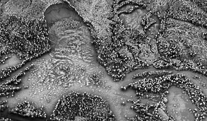
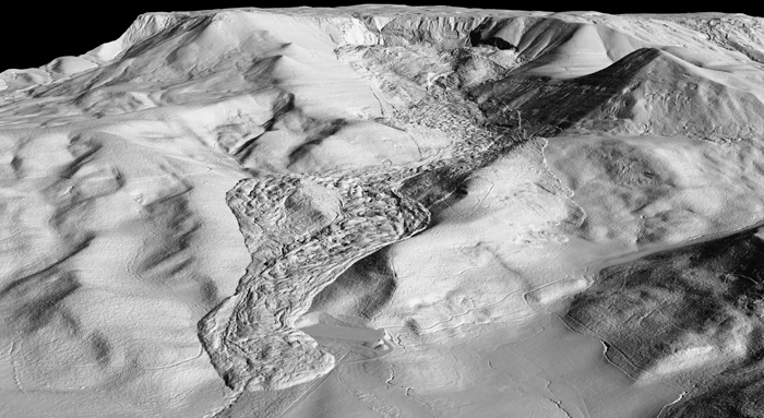
LiDAR (light detection and ranging) can help state, local and federal stakeholders to better gauge geological risks such as landslides. High resolution LiDAR modeling reveals subtle surface features that are undetectable via aerial photographs or field observation. LiDAR not only helps with landslide assessment and monitoring but can be used to target potentially susceptible landslide areas. This helps with mitigation planning, landscape modeling and protection of people and critical infrastructure.
Congressional Push
The U.S. Geological Survey’s (USGS) Landslide Hazards Program is the national clearinghouse for all landslide related matters. State legislators are pushing hard to increase this landslide focus and funding. In fact, U.S. House members who represent part of Snohomish County, WA sent a letter in May 2014 to key colleagues in Congress and to the President asking them to nearly triple the budget for the U.S. Geological Surveys’ Landslide Hazards Program. It’s getting some press. This would boost the program’s funding to $10 million, from about $3.5 million now. As a pioneer in the use of high density LiDAR, Quantum Spatial played a role by briefing the Washington Congressional delegation last April about the Oso landslide and the emergency services that we provided. We will be keeping an eye on more developments around this congressional push.
Quantum Spatial’s Recent Landslide Involvement
Quantum Spatial was in the air and on the ground at both Oso and Grand Mesa.
Within 24 hours of the Oso landslide, we were capturing LiDAR images of the massive debris field. Our LiDAR survey provided critical information for first responders, revealing with stunning clarity the extent of the disaster. Longer term, the analysis of the LiDAR data will be valuable for mitigation and restoration measures.
Quantum Spatial was also called upon for the Grand Mesa landslide. Within a few days of the slide, the Colorado Geological Survey, Colorado School of Mines, contracted with Quantum Spatial to collect high density LiDAR data over the landslide and surrounding area, for use in assessment and monitoring, mitigation planning, and landscape modeling. The data was successfully acquired within a week of the slide and terrain products were delivered within 10 days of acquisition.
Check back soon to see another post with an extensive image library of our involvement at Oso and Grand Mesa plus more about our pioneering work on landslide detection.