
Rail Solutions
We Take You in the Right Direction
Contact Us
Vegetation Management

Change Detection to Support Asset Management, GIS, & PTC
NV5 Geospatial change detection solution utilized client or NV5 Geospatial acquired lidar to perform automated change detection analysis. NV5 Geospatial solutions can leverage rail client’s existing GIS database to geofence assets to interest eliminating undesired change detection results caused by branches swaying in the wind, animals, and other false positives. Data can be processed and delivered on hard drives or provided within NV5 Geospatial’s cloud mapping solution ENVI Discover. Client’s can review and verify the result in ENVI Discover during rain or shine from the comfort of their desktop.
Rail Temperature Detection
Rail Branding Detection
Track Alignment Analysis
Engineering
Documentation
During construction – Track construction progress with a variety of our services such as periodic HD video, Orthophotography or Lidar. Conducted on a regular schedule, this monitors project status, analyzes problem areas and documents the completion of milestones for stakeholders and the public.
After construction – Create maps and 3D models of the as-built environment for reference files, GIS databases, Digital Twins, or to help launch future engineering work.
Contact Us
Rail
We are a solutions-based company focused on solving our client’s engineering, operation, regulatory, and maintenance challenges through the use of remote sensing technology. Our railway GIS services employ sensor and platform technologies. These include lidar, multi-spectral imagery, and thermal imagery on UAVs, trucks, hi-rail vehicles, railcar, helicopters, and fixed-wing aircraft for applications such as siting, vegetation management, track alignment, GIS & Asset Management, and engineering & design.
Vegetation Management
Save time and money by identifying clearance hazards without a site visit and make more informed decisions about when and where to deploy clearing crews. Our best in class utility vegetation management solutions include lidar-based clearance detection analytics, volumetric analysis, hazard tree detection, ROW tree inventory, change detection, species identification, predictive analytics, and our INSITE cloud application.
Rail Temperature Detection
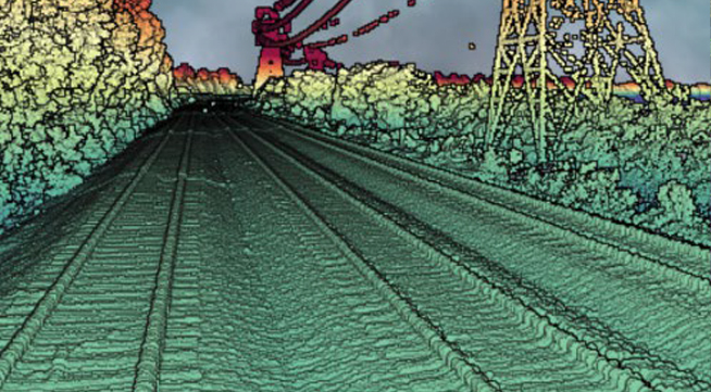
NV5 Geospatial’s custom Dual Long Wave InfraRed thermal sensor solution takes highly accurate measurements of the rail web along the entire track. The system consists of two, high frame rate (60Hz), exposure synchronized, radiometric thermal cameras designed to capture images at close proximity. Deliverables provide a more accurate way for clients to understand environmental effects and limitations to their system.
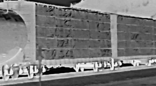
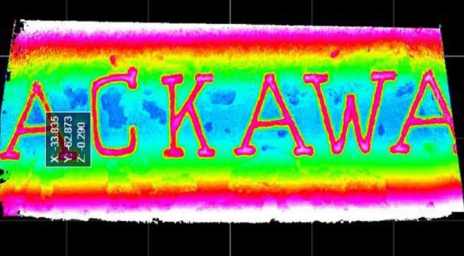
Rail Branding Detection
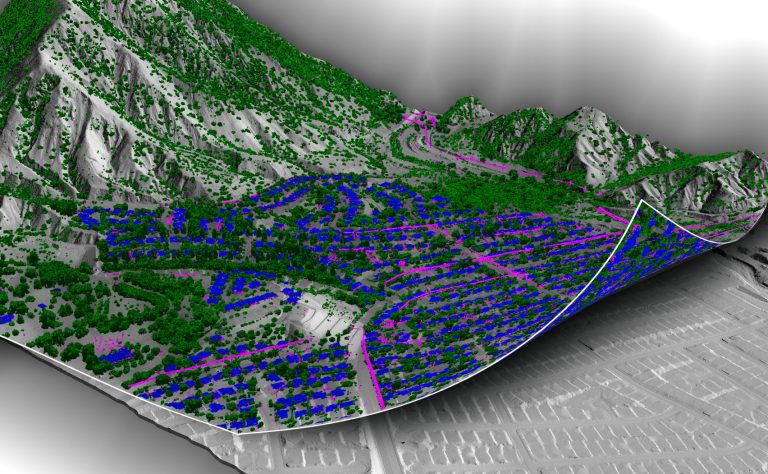
Change Detection to Support Asset Management, GIS, & PTC
NV5 Geospatial change detection solution utilized client or NV5 Geospatial acquired lidar to perform automated change detection analysis. NV5 Geospatial solutions can leverage rail client’s existing GIS database to geofence assets to interest eliminating undesired change detection results caused by branches swaying in the wind, animals, and other false positives. Data can be processed and delivered on hard drives or provided within NV5 Geospatial’s cloud mapping solution INSITE. Client’s can review and verify the result in INSITE during rain or shine from the comfort of their desktop.
Track Alignment Analysis
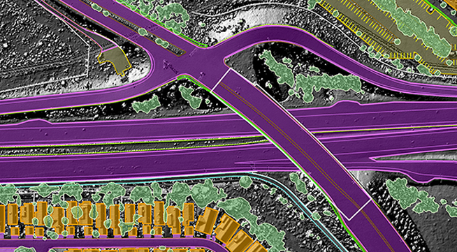
NV5 Geospatial supports rail companies in developing a Reference Track Surfacing (RTS) System by using high accuracy geodetic survey and lidar/imagery mapping. Our solutions incorporate mounting lidar and imagery equipment on a car for the duration of the project or leveraging existing lidar sensors owned by our clients. NV5 Geospatial will process and deliver these data focusing on accurately locating the track infrastructure features. This helps to develop existing corridor mapping and the horizontal and vertical track alignments. The information from the survey can be used to create precise geometric track alignments that provide safe, reliable and comfortable ride quality at high speeds.
Engineering Survey & Planning
NV5 Geospatial supports transportation design with large-scale mapping solutions, including low level/high accuracy lidar and low altitude photogrammetric mapping. From this data, NV5 Geospatial provides dense elevation point clouds, TINs, and mapping depicting closely spaced contours and detailed existing conditions. In addition, our high resolution orthophotography is considered by many engineers to be an indispensable design tool. Planners, environmental scientists and engineers depend on our data and expertise to make decisions for corridor studies, route realignments, and road and bridge improvements. NV5 Geospatial has extensive experience supporting light rail, high speed rail, and interstate rail infrastructure as well as environmental assessments. Our services support the assessment and characterization of environmental conditions required for permitting applications.
NV5 Geospatial’s rail branding solution utilizes proprietary sensor technology with great depth sensitivity. This is needed to derive recognize characters from rail web markings to determine and map rail segments manufacture and weight. We do not utilize passive imaging systems therefore no light or illumination is required. Additionally, by design the sensor is able to detect alpha numeric characters even when corrosion and weathering is present. NV5 Geospatial can delivery sensor data, character recognition results, and map these results. This provides clients with a better understanding of asset type, location, weight restrictions, and improve tracking and mitigation of defects across their entire system.