
By Matthew Renaud from Storm Water Solutions
Storm water regulations relating to construction sites vary across the country. Whether the project exists in a state with its own National Pollutant Discharge Elimination System Permit (NPDES) delegated authority or covered by the U.S. EPA’s Construction General Permit (CGP), the project may be required to sample a site’s storm water and non-storm water discharges. The focus here pertains to the California (CA) CGP’s requirements and will be the basis of this article’s permitting authority. The CA CGP requires Risk Level 2 and 3 Traditional (Linear Utility Projects have their own specific requirements) to sample and report storm water discharges from their site that originate from qualifying storm events (QSE) that are 0.5 inches or greater. Collecting discharge samples that are representative of the actual water quality is where the art and science of storm water sampling comes in to play.
Where a site discharged in a previous storm may not be where the site will discharge in a future storm. Additionally, the site may have added or removed discharge locations (inlets installed or removed). The pre-storm inspection or Rain Event Action Plan (REAP) plays an important role in defining the drainage areas and the likely percent volume represented by the identified discharge locations. Maintaining an up-to-date site plan will assist in calculating the area each discharge sample represents. The CA discharge Numeric Action Level (NAL) limitation averages for pH are between 6.5 and 8.5 and turbidity is 250 NTU. Since averaging pH can be a topic of multiple articles, this one will focus on turbidity and how a sampler should accurately account for variation in sample representation to determine whether an exceedance is actually occurring at the project site. To demonstrate this, below is a hypothetical site with the following observed conditions.
Based on the data above, would this site exceed the Numeric Action Level? Using straight math averaging (adding the values and dividing by 5), the turbidity would be an average of 270 NTU. That direct average value would be an NAL exceedance, requiring the Legally Responsible Person (LRP) to certify an ad hoc report that states that their site exceeded the NTU NAL discharge limit. But did this project really exceed the NAL for turbidity (>250 NTU)?
Using proportional representation of the samples, the values can be weighted to be representative of the discharge in totality. For this exercise, area weighting is used, not flow rate or volume weighting, which can be much more difficult to calculate in the field visually. To do this, calculate the samples proportionally by using the following equation:

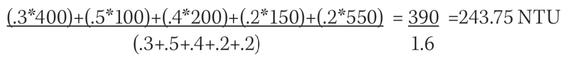
Based on this evaluation of the sampling data, the storm did not actually result in a turbidity NAL exceedance. This outcome is precisely why it’s important to understand and analyze the site’s discharge. The following considerations demonstrate the importance to have data accurately reflect the site:
- Identification of where project staff should focus their efforts and deploy Best Management Practice (BMP) materials to those areas that need the most improvement.
- NAL exceedances require that the project staff make improvements to existing BMPs to reduce the NTU value to meet the NAL. This will require additional BMPs, maintenance of existing BMPs and additional sampling to see if the improvements worked. If the exceedances still exist, rinse and repeat until either the discharges stop or nothing more can be done and the exceedance is reported.
- If the NAL exceedance is reported, the regulator may make the discretion to require the LRP to prepare an NAL Exceedance Report. This could also make the project vulnerable to the scrutiny of a third-party NGO that may want to file an action against the project for not complying with the permit.
Each of these actions will add costs. More labor hours for additional sampling and BMP installations and the added BMP materials will begin to run up project costs. With numerous ongoing projects in the regions, there may not be available BMPs for additional improvements during a rain event. It is ideal for projects to have a reserve amount of BMP materials onsite as it is a requirement of the CGP. Additional BMPs should be made available to help meet the NAL.
It’s also important to remember that an NAL exceedance is not a violation of the permit. The CA CGP currently does not have numeric effluent limitations for turbidity and pH, which if violated, are violations of the permit. Exceeding an NAL means that the project’s discharge is above the targeted water quality goal set by the regulation. The project is required to make continuous attempts to improve their discharges to bring their values in compliance with the NAL thresholds to the best of the ability of the project through the use of the best available technologies. Documenting the steps taken in each derivative step will keep the regulators and third-party NGOs away from finding a permit violation and assessing monetary violations.
Ultimately, a sampler’s ability to understand what the data represents is a key factor in the amount of additional effort and potential regulatory interest a site will receive. Reporting and interpreting data accurately, and within the confines of what the permit affords, can be advantageous to the project and the bottom line.
Click here to read this article on the Storm Water Solutions website.