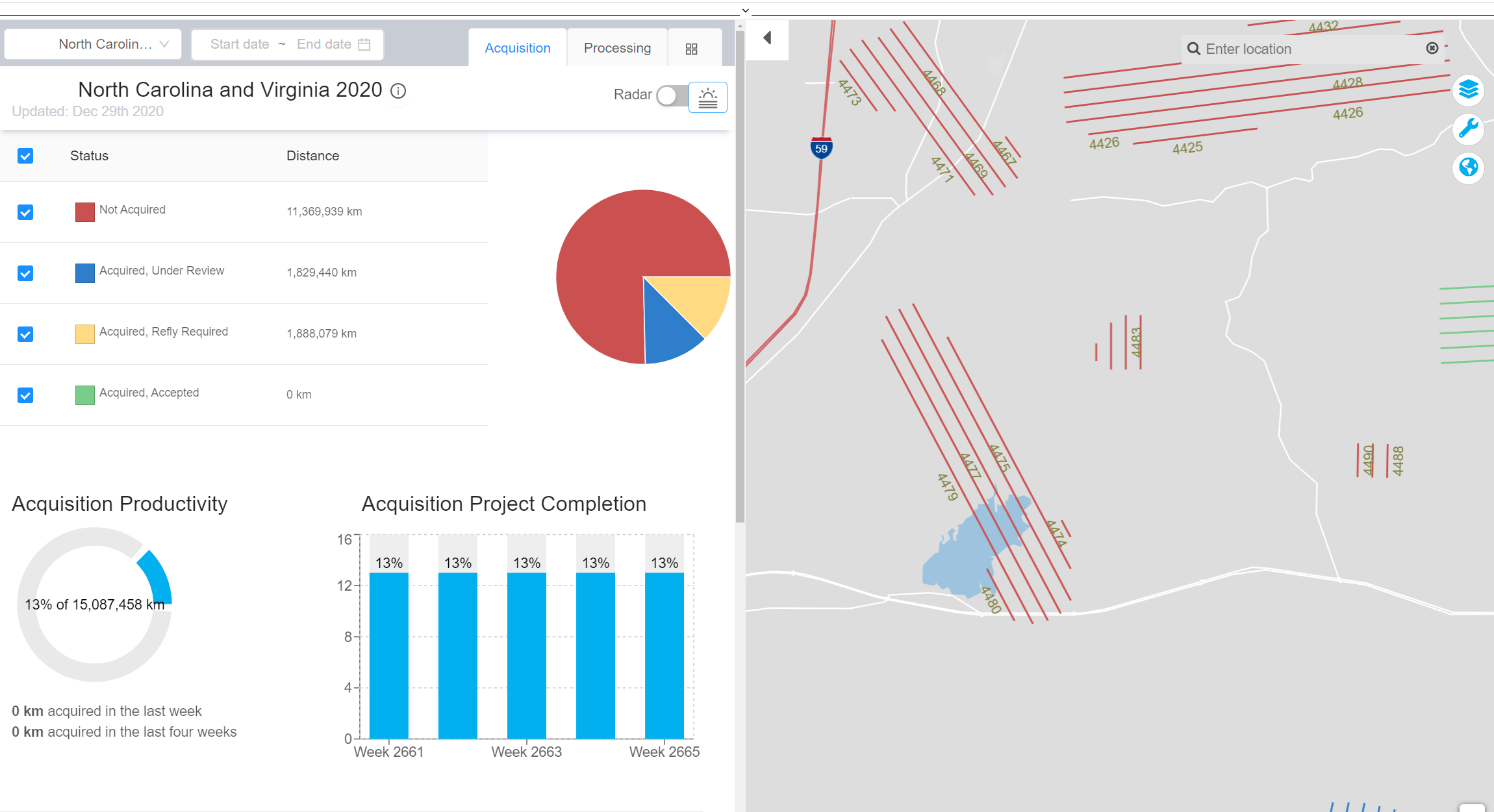
NV5 Geospatial’s INSITE LIFECYCLE combines project tracking with data quality assurance and control. Providing instant access to geospatial data allows for a collaborative QA/QC of imagery and lidar derivatives, letting you track progress in real-time and review and flag issues for more responsive reprocessing. LIFECYCLE app puts data at your finger tips via cloud-based “contactless” data delivery. Fill out the form to gain access to the webinar recording.
Matt Nugent, Director of INSITE presents LIFECYCLE capabilities and functionality in detail via webinar.
Matt has over a decade of experience implementing solutions and creating products that assist organizations with some of the largest operational challenges they face. Matt understands the value of spatial data and has focused on creating applications that handle the problem sets remotely sensed “big data” creates for the organizations so they can get the most from their data
Project Tracker + QA/QC + Data Delivery = INSITE LIFECYCLE
Fill Out Form to View Webinar
Fill out the form below to download the handbook.
Form #1 - Redirection to PDF
Form #2 - Sends email containing the link to the PDF
"*" indicates required fields
eNewsletter - NV5 Real Estate Transaction Services
Contact NV5 Real Estate Transaction Services
Download NV5 2022 Compliance Calendar
Please fill out the form below. After successful form submission, you will be redirected to the requested file. Thank you.
"*" indicates required fields
Hyperspectral Imaging - Technically Speaking
Our internal innovation and development team constantly analyzes new technology and develops solutions to meet our client’s challenges. Our Technically Speaking series is one way we share our technical findings with the professional community.
Please tell us a little about yourself by filling out the form below, and we’ll share the document with you, thanks!
Accuracy Part 1- Technically Speaking
Our internal innovation and development team constantly analyzes new technology and develops solutions to meet our client’s challenges. Our Technically Speaking series is one way we share our technical findings with the professional community.
Please tell us a little about yourself by filling out the form below, and we’ll share the document with you, thanks!
Prune Optimization Webinar Recording
NV5 Geospatial releases a new predictive modeling platform for vegetation management that uses existing lidar and historical data to identify the relative level of asset risk from trees by quantifying the potential for causing asset damage.
Please tell us a little about yourself by filling out the form below, and we’ll share the document with you, thanks!
Topobathy Lidar - Technically Speaking
Our internal innovation and development team constantly analyzes new technology and develops solutions to meet our client’s challenges. Our Technically Speaking series is one way we share our technical findings with the professional community.
Please tell us a little about yourself by filling out the form below, and we’ll share the document with you, thanks!