Search
Archives

Bringing Life to Water Street’s ‘Deadening Pedestrian Experience’

March 16, 2016

By
CARL GLASSMAN / TribecaTribOnline

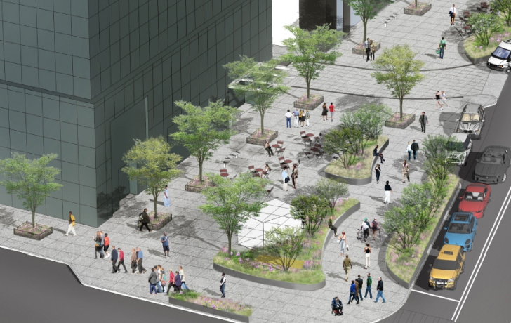
Plans are afoot to make pedestrian-unfriendly Water Street more welcoming.

New plaza designs, wider sidewalks and a unified streetscape are among the features slated for the street’s five southern-most blocks—between Whitehall Street and Hanover Square.

“This is the beginning of our efforts to reimagine how this corridor looks,” said Josh Nachowitz, an economic development official at the Downtown Alliance, which is planning the project with the city. “To take what is a deadening pedestrian environment and turn it into a 21st-century commercial corridor.”

The five blocks of Water Street, from Whitehall Street to Hanover Square, with design improvements meant to give a unified look to the street. Diagram by the RBA Group
Nachowitz and other planners presented preliminary designs of the improvements this month to Community Board 1’s Planning Committee. The designs grow out of an initiative begun in 2010 by the Alliance to look for ways to enhance Water Street from Whitehall to Fulton, a stretch of street lined with office towers that Nachowitz said is the largest concentration of high-grade commercial buildings in Lower Manhattan, “hugely important to the economy of the business district.”

In 2013, Water Street between Whitehall and Hanover Square was narrowed by a lane, allowing for a wider walkway, and two temporary plazas were created, laid out with epoxy gravel, pavement striping, plastic bollards and other materials.

Construction of the redesigned plazas and other permanent improvements are expected to begin by spring 2017.

The Lower Manhattan Development Corp. provided $10 million for the remaking of these five blocks, only a portion of the estimated $23 million that is needed to remake the entire streetscape up to Fulton. Officials said they are looking to the LMDC for the remaining funds.

A completed Whitehall Plaza, as it is to be called, will allow its visitors to be “somewhat protected from the noise and the traffic and the heavy wind that blows,” said Jackson Wandres, a landscape architect with the RBA Group, the project consultants.

Moveable tables and chairs, partially shielded by raised plant beds rimmed with heavy-duty, galvanized steel walls, would include spaces for additional seating.

Moore Street, which dead-ends at Water Street and runs through Whitehall Plaza, would be raised to the same level as the plaza, with the same paving materials “so the space will feel unified and vehicles will know to slow down when they’re crossing the plaza space,” Wandres said.

Rendering of proposed Whitehall Plaza and (inset) the space today, with temporary paving, bollards and striping. In 2013 a traffic lane, at right, was taken over for pedestrian and where the plaza is proposed to expand. The white area shown in the rendering is the location of a future commercial kiosk. Rendering: RBA Group/Photo: Tribeca Trib

At Coenties Slip Plaza, a triangular park between Water and Pearl Streets, changes to paving materials and planters, along with new tree pits and benches will give the space “a more integrated and cohesive feeling,” Wandres said.

Missing from the plan, cycling advocates complained, is a bike lane.

“It’s a very natural and important corridor to have a bike lane,” said Charles Komanoff, a cycling activist and energy policy analyst, who called the street “really dangerous” for bike riders.

Rich Carmona, a Department of Transportation planner and engineer who worked on the project, said the feasibility of a bike lane on Water Street was studied, and it was determined that truck loadings, taxi pickups and drop offs and buses made the idea unworkable.

The cross section of a raised plant bed, or berm, that is the type proposed for Whitehall Plaza. Subsurface “Silva Cells” allow tree roots to grow under the sidewalk. Diagram by the RBA Group

“We decided as an agency to focus our attention as cyclists onto

The cross section of a raised plant bed, or berm, that is the type proposed for Whitehall Plaza. Subsurface “Silva Cells” allow tree roots to grow under the sidewalk. Diagram by the RBA Group

South Street where we are implementing a grade-separated cycle track” that is protected, Carmona said.

“I think that’s a terrible decision,” Komanoff replied. “I haven’t been on South Street in years. It’s not my desire or others, I think, who are trying to get somewhere.”

Esther Regelson, who said she frequently rides on Water Street, agreed. “It’s just a crucial corridor for us right now,” she said. “South Street is not because, first of all, it’s full of tourists.”

In a resolution, CB1 also called for a bike path along Water Street. The design must win the approval of the city’s Public Design Commission and Economic Development Corporation before going forward.

Fill out the form below to download the handbook.

Form #1 - Redirection to PDF

Form #2 - Sends email containing the link to the PDF

"*" indicates required fields

This field is for validation purposes and should be left unchanged.

eNewsletter - NV5 Real Estate Transaction Services

Contact NV5 Real Estate Transaction Services

Download NV5 2022 Compliance Calendar

Please fill out the form below. After successful form submission, you will be redirected to the requested file. Thank you.

"*" indicates required fields

We are an equal opportunity employer. All applicants will be considered for employment without attention to race, color, religion, sex, sexual orientation, gender identity, national origin, veteran or disability status. We ensure nondiscrimination in all programs and activities in accordance with Title VI of the United States Civil Rights Act of 1964. If you need more information or special assistance for persons with disabilities or limited English proficiency, contact MaryJo OBrien at (954) 495-2112. Persons with hearing-and speech-impairments can contact the NV5 by using the Virginia Relay Service, a toll-free telecommunication device for the deaf (TDD). Call 711 for TTY/TDD.
This field is hidden when viewing the form
This field is for validation purposes and should be left unchanged.

Hyperspectral Imaging - Technically Speaking

Our internal innovation and development team constantly analyzes new technology and develops solutions to meet our client’s challenges. Our Technically Speaking series is one way we share our technical findings with the professional community. 

Please tell us a little about yourself by filling out the form below, and we’ll share the document with you, thanks!

Accuracy Part 1- Technically Speaking

Our internal innovation and development team constantly analyzes new technology and develops solutions to meet our client’s challenges. Our Technically Speaking series is one way we share our technical findings with the professional community. 

Please tell us a little about yourself by filling out the form below, and we’ll share the document with you, thanks!

Prune Optimization Webinar Recording

NV5 Geospatial releases a new predictive modeling platform for vegetation management that uses existing lidar and historical data to identify the relative level of asset risk from trees by quantifying the potential for causing asset damage. 

Please tell us a little about yourself by filling out the form below, and we’ll share the document with you, thanks!

Topobathy Lidar - Technically Speaking

Our internal innovation and development team constantly analyzes new technology and develops solutions to meet our client’s challenges. Our Technically Speaking series is one way we share our technical findings with the professional community. 

Please tell us a little about yourself by filling out the form below, and we’ll share the document with you, thanks!

Contact Geospatial

Contact Geospatial