
Facility Management
Know Your Space
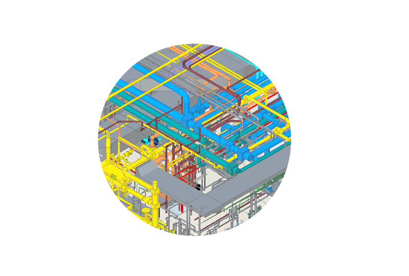
Facility Mapping
NV5 empowers facility managers by providing detailed 3D indoor and outdoor maps of your facilities. Our mapping solutions enable you to visualize and manage your space effectively, leading to improved space utilization and operational efficiency.
Indoor Routing
NV5’s indoor routing solutions create a digital twin of your facility, allowing for seamless coordination between monitoring systems. This enhances situational awareness, streamlines navigation, and supports optimal space management planning.
Asset Inventory
Maintaining an accurate inventory of your facility’s assets is crucial for efficient management. NV5 offers real property inventory and reconciliation services to ensure that your assets are accounted for and managed effectively, reducing operational risks.
We offer tailored solutions to empower facility managers- including comprehensive mapping, indoor routing, real property inventory, and access to critical information. With NV5’s geospatial solutions, you can enhance facility operations and security, ensuring the success and safety of your organization. Contact us to learn more >>
How We Help
For over a decade, the NV5 team has helped organizations build and maintain a cloud system that fits within their overall strategy. In addition to full implementation support, we provide ongoing software updates and ad hoc support so your cloud-based system will work for years to come.
To optimize architecture within your existing environment, you need a strong understanding of the technical, functional, and utilization requirements. Our team uses Esri tools and models to help you identify deployment patterns, optimize your system’s performance, and minimize cost. We follow the latest best practices and work within your security constraints to meet your organizational objectives.
In our world, nothing ever stays the same—and the same applies to your organization. To answer the big questions your organization faces, you need to integrate your business system data with geospatial data.
NV5 helps you utilize your geospatial solution as an integration engine to provide a comprehensive view of your organization’s data. We will teach you how to use your solutions to monitor data and identify trends, so you can make the best decisions for the people you serve.
The world may be constantly in flux, but your organization’s success does not have to be. Schedule a meeting now, and we will work together to identify the best solutions for your specific challenges and goals.
As a Cityworks Partner, we bring a unique perspective to the implementation and optimization of Cityworks for workflows of all kinds. Our team has a combined 85+ years of experience with Cityworks. We specialize in tailored deployments, training, and integrations with Cityworks Platform based on your specific needs.
We don’t just set up Cityworks and leave. We ensure your organization has what it needs to utilize Cityworks to be successful. Together, we will make sure that your processes work seamlessly, so your team can stop wasting energy doing tasks they shouldn’t have to and start focusing on the tasks they enjoy.
As a certified ESRI Platinum Partner, NV5 is the leader in providing ArcGIS-based solutions to clients including specialty applications:
- Utility Network Management
- Cloud Services
- Indoors
- System Ready
- State & Local Government
Our team’s deep understanding of the FAR, commercial licensing, and customer use cases enables you to fast-track the adoption of your data into an agency’s operation. We will set you up for success with source harvesting, data evaluation, licensing negotiations, terms of service, and data adoption.
Reality capture techniques are becoming a staple for data collection procedures. Performing advanced analytics and data extraction or detection against these large datasets can be daunting and overwhelming.
GeoAI combines methods geospatial professionals have been using for years with Machine Learning and AI through high-performance computing to extract meaningful knowledge through automated processes.
NV5 helps organizations leverage these new techniques in data collection, extraction and integration into existing business systems that allows an extended reach into spatial analytics which improves the overall decision making process.
NV5 specifically provides strategic alignment for planning, managing and executing an asset capturing project at any scale using the reality-capturing techniques and GeoAI methodologies.
The results are a comprehensive asset inventory and attribution of your organization’s most critical and valuable infrastructure.
You want accurate, useful, and easy-to-understand cartographic products. What you don’t want is the additional stress of adjusting your map documents to bring your vision for the products to life.
Our trained cartographers balance the science of data with the art of presentation. With more than 20 years of experience building charts and the standards that govern the charts, we can provide you with a proven, high quality, and scalable production model to meet any scale or chart domain.
We create cartographic products that are rich with data but remain easy to read. Our cartography experts condition data to prepare and package dataset inputs for cartographic production.
We use expert analysis to combine multiple sources into a cohesive dataset that incorporates the best of each, so you can instantly gain insights and determine your next steps. To improve efficiencies and the quality of your end product, we always follow clear procedures and make the most out of automation.
Facility Management Using ArcGIS as a Catalyst for Integration & Collaboration
Join our very own Geospatial Innovation Strategist, Steve Mulberry, as he presents how ArcGIS can enhance integration, collaboration, and workflows, highlighting its potential as an enterprise GIS that incorporates emerging technologies like IoT and AI to support facility managers with analytical and visual analysis.
WEBINAR- Geospatial Digital Twins for Facilities and Vertical Asset Management
We explore the use of geospatial digital twin technologies in solving facilities and vertical asset management challenges. Along with guest speakers from Esri, our team discusses the benefits of using geospatial solutions to improve operations and decision-making, including various tools and techniques that can be employed to address specific challenges. View Webinar