Marron and Associates (Now NV5) is an environmental consulting firms with a long tradition of providing a full range of environmental services within New Mexico and the southwest. Marron offers our clients a staff of professionals in a wide range of technical fields. We specialize in preparing all levels of environmental documentation (often pursuant to NEPA), biological and cultural resource investigations and reporting, and regulatory permitting and compliance.
All photography provided by Paul Knight
Press Release Marron & Associates
Ready to take your project to the next level? One of our friendly staff is ready to assist you.

Marron has a broad base of experience that covers a full range of services requiring cultural resource compliance and consultation. Our services include all aspects of cultural resource management — from site file searches to data recovery; from attending project team meetings to presenting before the Cultural Properties Review Committee (CPRC); and from preparing text for programmatic agreements to having our work reviewed by the Advisory Council on Historic Preservation. Our seasoned archaeologists have worked throughout the state, have the ability to work on all public and state lands, and meet the Secretary of the Interior’s Professional Qualification Standards. Marron is experienced with the Section 106 process of the National Historic Preservation Act of 1966 (NHPA), New Mexico Historic Preservation laws, and specific guidelines of each land management agency [e.g., the Bureau of Land Management (BLM), the U.S. Forest Service (USFS), and New Mexico State Land Office (SLO)]. As is so important in obtaining clearances, Marron has built excellent relationships with the regulatory and resource agencies, including the State Historic Preservation Officer (SHPO). Marron also maintains relationships with many of the tribes and pueblos in New Mexico, which facilitates our ability to conduct tribal consultations regarding sensitive areas and traditional cultural properties. Marron personnel include specialists in prehistoric and historic archaeology, history, architectural history, historic preservation planning, artifact curation, urban archaeology, and Historic American Buildings Survey/Historic American Engineering Record (HABS/HAER) documentation. A Geographic Information Systems (GIS) specialist, an editor, an Information Technology (IT) specialist, and administrative staff support our technical personnel.


The latest Cloud-based technology systems from ESRI and Trimble are utilized by our teams in the office and in the field.

With the recent expansion of services at our Albuquerque office, NV5 now offers its cutting-edge UAV (drone) services to markets in the southwest. Aerial mapping can reduce the survey cost of your project and is particularly helpful when surveying expansive, remote, harsh, or hazardous areas. We have more than 100 certified licensed pilots on staff, and a Certificate of Waiver or Authorization (COA) to operate at night. Even if you are not ready to map your site, we can acquire the imagery now and hold it until you are.
We are pleased to offer UAV (drone) services to the New Mexico, Arizona, Southern Colorado and West Texas markets. Our level of experience and expertise is unmatched, so don’t hesitate to reach out to us for more information.
High resolution aerial photography and accurate elevation contours enable our clients to make better informed decisions with greater efficiency. Inquire with us for a free consultation. We will craft a UAV solution tailored to your precise needs. 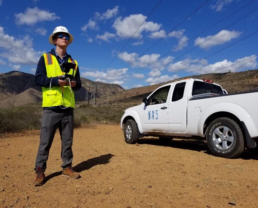
NV5 has over 100 registered pilots nationwide (including New Mexico) and can respond quickly to needs in any region of the country.

NV5’s staff is experienced with the broad requirements and agency-specific procedures needed to successfully apply NEPA when needed and to prepare agency-specific documents, including categorical exclusions (CEs, CXs, or CATEXs), environmental assessments (EAs), environmental impact statements (EISs), environmental reports (ERs), and environmental information documents (EIDs). Depending on the agencies involved and level of environmental effort, Marron’s documents typically examine the proposed action and alternatives; incorporate the findings of resource surveys that identify the affected environment; analyze data to determine impacts of the proposed alternatives; and provide recommendations and mitigation measures. Therefore, successfully navigating the environmental clearance process requires an in-depth understanding of the lead agency’s standard procedures, permitting agency requirements, public and stakeholder concerns, and deep expertise in resource issues, impact analysis, and impact avoidance, minimization, and mitigation measures—all of which NV5 brings to the table. NV5’s environmental analysts include specialists who have completed thousands of documents to differing agencies’ standards; who have developed strong relationships with the local, state, and federal resource and land managing agencies, as well as many of the tribes and pueblos; who are experienced with public outreach efforts; who routinely prepare, plan, and analyze/review technical studies and permit applications; and who understand the different industries NV5 supports, many sectors including energy; housing; infrastructure; oil and gas; transportation; utilities; water, sewer, and wastewater treatment; and private and commercial development. Geographic Information Systems (GIS) specialists, an editor, an information technology (IT) specialist, and administrative staff support our technical personnel. Environmental Science and Planning Services include:


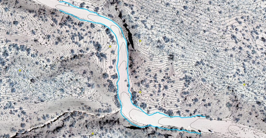
NV5’s New Mexico (based in Albuquerque) GIS personnel include two full-time GIS specialists with over 18 years of combined professional GIS experience. With a broad range of experience in all aspects of applying GIS to the field of environmental science and planning, our GIS staff works hand-in-hand with our clients to customize mapping for immediate and long-term solutions. NV5’s national network of GIS specialists allow us to provide robust GIS solutions to our clients at any scale. We specialize in ESRI software and Trimble hardware, but we also provide AutoCAD and Topcon Total Station solutions when our clients require it. Many of our staff members are trained and proficient in GIS and can support our GIS department on large-scale projects, both in the office and in the field. Geographic Information Systems Services include:
Resources:

High resolution aerial photography and accurate elevation contours enable our clients to make informed decisions with greater efficiency. Inquire with us for a free consultation. We will craft a GIS solution tailored to your precise needs. 
The latest Cloud-based technology systems from ESRI and Trimble are utilized by our teams in the office and in the field.

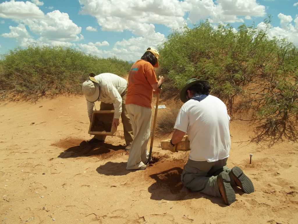
Marron’s biologists are experienced in providing accurate and concise biological resource documents for terrestrial, aquatic, and riparian habitats as well as wetland project sites throughout New Mexico. We provide general and species-specific biological surveys as well as produce all levels of documentation, including technical memoranda, agency-specific reports, full biological assessments/evaluations, wetland determination/delineations, wetland mitigation plans and monitoring documentation, and Clean Water Act (CWA) permitting. General biological surveys include an inventory of vegetation and wildlife present within a site; analyses of habitat suitability for rare, threatened, and endangered species; and the potential for project effects/impacts to sensitive resources. In addition, we provide identification of migratory bird nest sites; location of raptor roost or nesting sites; documentation of terrestrial wildlife corridors; identification of bat roost locations; and vegetation studies for percent cover, frequency, density, and composition of floristic communities. Marron also conducts species-specific protocol surveys as required by federal, state, or tribal agencies and maintains a departmental permit to provide surveys within Navajo Nation lands.
Marron also has extensive experience in the identification, determination, and delineation of wetlands, including the completion of hundreds of wetland determinations and delineations and coordination with the U.S. Army Corps of Engineers (USACE). Marron also provides wetland mitigation plans including both conceptual and final plans. Such plans include designs for riparian floodplains, ephemeral waterways and intermittent waterways, perched water tables, and runoff within urban waterways. Marron also conducts monitoring during construction of wetlands as well as long-term monitoring of created wetlands to ensure that required performance standards are achieved.

Discharges of dredge or fill material into waters of the United States (perennial, intermittent, or ephemeral) rivers, streams, washes, or arroyos and adjacent wetlands within the jurisdiction of the USACE may require CWA Section 404 permitting and Section 401 water quality certification. Marron identifies ordinary high water mark location, provides complete permit applications and associated 404(b)(1) alternatives analyses when required, or completes a preconstruction notification for the use of the nationwide permitting system when notification is required. Discharges of stormwater or other municipal runoff into waters of the United States may require coverage under the CWA Section 402 National Pollutant Discharge Elimination System. Municipalities and associated large operators may be required to obtain authorization for such discharges from the U.S. Environmental Protection Agency (USEPA), which is provided as a multi-year Municipal Separate Storm Sewer System (MS4) permit.
The latest Cloud-based technology systems from ESRI and Trimble are utilized by our teams in the office and in the field.

Marron works throughout New Mexico on public, private, and tribal lands. We have prepared Phase I ESAs throughout New Mexico in locations such as Acoma Pueblo, Albuquerque, Artesia, Belen, Bernalillo, Bosque Farms, Carlsbad, Chaves County, Clovis, Cuba, Deming, Edgewood, Española, Eunice, Farmington, Gallup, Grants, Hobbs, Isleta Pueblo, Jicarilla Apache Nation, Laguna Pueblo, Las Cruces, Las Vegas, Los Lunas, Pojoaque Pueblo, Navajo Nation, Santa Fe, Silver City, Tesuque Pueblo, and Truth or Consequences. Avoiding the Unexpected in Property Transactions No one likes unexpected problems. Hazardous materials sites are found throughout New Mexico and can surprise the unsuspecting land purchaser. When purchasing or transferring property, government agencies, independent districts, and private companies need Phase I Environmental Site Assessments (ESAs) to complete secure property transactions. Government agencies require Phase I ESAs to minimize liability risk when acquiring property. Banks require Phase I ESAs for commercial property transactions. Marron and Associates (Marron) provides responsive Phase I ESAs services tailored to meet client transaction and schedule requirements. Phase I ESA Process Marron adapts the Phase I ESA process to best serve our clients’ needs. We follow the American Society of Testing and Materials (ASTM) Standard E 1527-13: Standard Practice for Environmental Site Assessments: Phase I ESA Process. This practice constitutes all appropriate inquiry into the previous ownership and uses of the property consistent with good commercial or customary practices as defined in 42 USC §9601(35)(B). For more information contact: Eric Johnson, AICP CHMM Senior Environmental Project Manager 


Ecological and Cultural Resource Studies for Navajo Area Uranium Mines
The USEPA proposed to remove mine waste from four former uranium mines in the Ambrosia Lake Sub-District, north of Grants, McKinley County. Marron was tasked with completing ecological and cultural resource studies over 2,300 acres, which included private, state and federal lands. The ecological services included surveys for rare, threatened and endangered species, and identifying critical habitats. Marron also installed monitoring vegetation transects, developed a vegetation map, identified and mapped wetlands, compiled wildlife data and information on ecological conditions, surveyed for raptors, and documented soil types and waterways. After fieldwork was completed and an analysis of the findings was conducted, Marron prepared a Natural Resources Evaluation Report that included a biological evaluation section to address potential impacts to threatened and endangered species and included recommendations to minimize impacts. With respect to cultural resources, seven sites and 180 isolated occurrences were found and recorded. As part of the survey process, client representatives accompanied the field crew and completed Ludlum Scaler Ratemeter readings for every cultural resource found. A variety of cultural sites were recorded including Ancestral Pueblo and historic artifact scatters, historic homesteading, and mining-related sites. Treatment recommendations were based on site eligibility, proposed activities in the area, the Ludlum Scaler Ratemeter reading, and the specific cultural resource found. Marron worked closely with the client to determine treatment recommendations and the survey. All documents were completed on time and within budget.
Picuris Pueblo Solar Generation Facility
The Pueblo of Picuris (Pueblo) and the Northern Pueblos Housing Authority proposed to construct and operate a solar photovoltaic facility, which would consist of a ground-mounted, single-axis array. When operational, the solar panels would tilt to track the angle of the sun to obtain maximum energy. The electric power produced would be fed into the grid and be purchased by a local electrical co-operative. The revenue stream from the sale of power would go primarily to the Pueblo and to provide a return to a private equity investor. The Pueblo would use a portion of the revenue to cover energy costs for the Pueblo and its members, making Picuris Pueblo energy independent and creating a viable model for other tribes. Additionally, by using solar energy, the Pueblo would reduce fossil fuel energy use and carbon dioxide emissions, which contribute to global climate change.
Marron prepared an environmental assessment (EA) for the approval of a lease for development of the property. Funding for the project included grants from the Department of Energy, Bureau of Indian Affairs, and Enterprise Community Partners. Marron also conducted biological and cultural resource investigations for this project. The Bureau of Indian Affairs issued a Finding of No Significant Impact.
Laguna Wastewater and Sewer Project
This large survey incorporated all resource- and inventory‑related tasks, including an environmental assessment and biological and cultural surveys and corresponding reports. The undertaking consisted of an extensive stimulus‑funded upgrade to the waste water system of Laguna Pueblo with the project area consisting of a web of linear pipeline corridors covering much of the Pueblo. The project involved extensive preliminary planning and consultation with the agencies, tribal officials, and engineers. Resources encountered during the survey included a wide variety of prehistoric and historic archaeological sites, numerous historic buildings (commercial, residential, and civic), five extensive acequia systems, portions of historic Route 66, and traditional cultural properties. Biological resources such as wetlands, waterways, protected species habitat, and migratory bird nesting habitat were identified. Marron completed its assigned task on schedule and assisted in the preparation of a Federal Emergency Management Agency Programmatic Agreement to allow the project to move forward with the assurance that additional necessary work will be conducted as needed. Marron was awarded the second phase of this long multi‑year project.