NV5 recognized for coastal resiliency efforts with MAPPS award for Albemarle Sound Hydrographic Survey

Albemarle Sound Hydrographic Survey

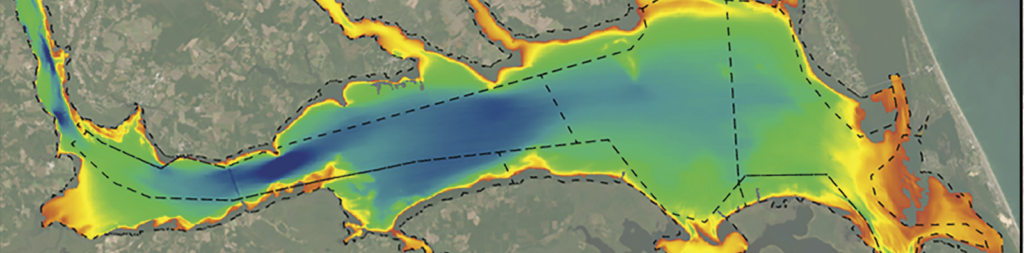
The Albemarle Sound, one of the longest estuaries in North Carolina, spans from the Outer Banks to expansive wetlands, rivers, and marshes. NOAA’s Office of Coast Survey (OCS) contracted NV5 to survey the bathymetry of the Sound, a region that hadn’t been surveyed for navigation or marine hazards since the 1920s.

NV5’s survey covered 475 square nautical miles, using a pioneering Coastal Resilience Charting approach. The resulting high-resolution bathymetric products will update NOAA’s nautical charts and support coastal resilience modeling, including inundation mapping, salinity gradient mapping, and habitat mapping.

Innovative Survey Approach: The survey area posed unique challenges due to its shallow nature and lack of modern bathymetric data. NV5 deployed a fleet of six survey platforms, including two Uncrewed Surface Vessels (USVs), to capture data across varying depths and conditions. Multibeam echosounders (MBES), singlebeam echosounders (SBES), and sidescan sonar (SSS) sensors were used to map the bathymetry, capture seabed sediment characteristics, and identify potential hazards.

Data Management and Quality Control: To manage the large volume of data, NV5 developed a customized GIS solution, the Survey Information Management System (SIMS), for real-time data validation and project management. SIMS enabled NV5 to perform quality control on mosaics and assess data line-by-line. This approach also uncovered over 100 previously uncharted dangers to navigation (DToNs).

Meeting Dual Objectives: NV5 adapted its data processing workflow to meet both nautical charting and coastal resilience objectives. By blending different mapping and processing software, NV5 ensured the data complied with NOAA’s nautical charting standards while also supporting coastal resilience efforts.

Fill out the form below to download the handbook.

Form #1 - Redirection to PDF

Form #2 - Sends email containing the link to the PDF

"*" indicates required fields

This field is for validation purposes and should be left unchanged.

eNewsletter - NV5 Real Estate Transaction Services

Contact NV5 Real Estate Transaction Services

Download NV5 2022 Compliance Calendar

Please fill out the form below. After successful form submission, you will be redirected to the requested file. Thank you.

"*" indicates required fields

We are an equal opportunity employer. All applicants will be considered for employment without attention to race, color, religion, sex, sexual orientation, gender identity, national origin, veteran or disability status. We ensure nondiscrimination in all programs and activities in accordance with Title VI of the United States Civil Rights Act of 1964. If you need more information or special assistance for persons with disabilities or limited English proficiency, contact MaryJo OBrien at (954) 495-2112. Persons with hearing-and speech-impairments can contact the NV5 by using the Virginia Relay Service, a toll-free telecommunication device for the deaf (TDD). Call 711 for TTY/TDD.
This field is hidden when viewing the form
This field is for validation purposes and should be left unchanged.

Hyperspectral Imaging - Technically Speaking

Our internal innovation and development team constantly analyzes new technology and develops solutions to meet our client’s challenges. Our Technically Speaking series is one way we share our technical findings with the professional community. 

Please tell us a little about yourself by filling out the form below, and we’ll share the document with you, thanks!

Accuracy Part 1- Technically Speaking

Our internal innovation and development team constantly analyzes new technology and develops solutions to meet our client’s challenges. Our Technically Speaking series is one way we share our technical findings with the professional community. 

Please tell us a little about yourself by filling out the form below, and we’ll share the document with you, thanks!

Prune Optimization Webinar Recording

NV5 Geospatial releases a new predictive modeling platform for vegetation management that uses existing lidar and historical data to identify the relative level of asset risk from trees by quantifying the potential for causing asset damage. 

Please tell us a little about yourself by filling out the form below, and we’ll share the document with you, thanks!

Topobathy Lidar - Technically Speaking

Our internal innovation and development team constantly analyzes new technology and develops solutions to meet our client’s challenges. Our Technically Speaking series is one way we share our technical findings with the professional community. 

Please tell us a little about yourself by filling out the form below, and we’ll share the document with you, thanks!

Contact Geospatial

Contact Geospatial