NV5 and USGS Release High Resolution Lidar Data of Palisades Fire and Eaton Fire Burn Areas to the Public

Lidar data collected by NV5 can help quantify fire damage, identify areas at risk of debris flows or flooding, and guide restoration efforts. 

  LOS ANGELES, Calif., January 30, 2025NV5, the world’s leading provider of geospatial software and services, today announced that lidar-derived data of the Palisades Fire and the Eaton Fire burn areas are now freely available to the public courtesy of the U.S. Geological Survey (USGS) at 2025 Post-Wildfire Lidar Data for Los Angeles, CA. The data is a .5 meter Digital Elevation Model (DEM) and Digital Surface Model (DSM). ALERTCalifornia sponsored the lidar data acquisition. 

  The provisional lidar data was collected January 21- January 22, 2025, and can be used to analyze the devastating fires’ impact and provide insights for damage assessment, which is critical for recovery and rebuilding efforts, as well as for better understanding potential hazards due to debris from the fire.  

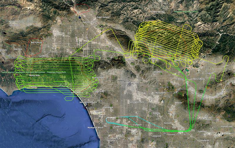
"The Palisades and Eaton fires not only devastated and tore apart the lives, homes, businesses and neighborhoods of thousands of Angelenos, they have also shown the world that cities, counties and jurisdictions across the globe can be hit with devastating fires in our warming world. We are pleased to provide the community with the lidar data as it is essential to developing effective and time-critical plans for wildfire prevention, protection, mitigation, response and recovery."

The lidar data collected of the fire burn areas can measure changes in terrain, vegetation density, and burn severity by comparing it to precise 3D point clouds from previous lidar data collection by NV5 in 2023 and 2024 in support of the USGS’s 3D Elevation Program (3DEP) partnership with the Los Angeles Region Imagery Acquisition Consortium (LARIAC) Program . This analysis helps quantify fire damage, identify areas at risk of debris flows or flooding, and guide restoration efforts. Lidar can also detect remaining hazards like unstable trees, compromised structures and infrastructure, as well as supporting safe recovery operations. NV5 acquired the new lidar data with a Riegl 1560II and Applanix IMU. The burn zones were flown at 16 points per square meter and will undergo additional processing to fully comply with USGS 3DEP Lidar Base Specification Standards. 

“In our changing world, it's critical that the public, first responders, city, state, government planners, utilities, private companies, and builders have consistent, highly detailed information about the local geography to make sure they are armed with the information they need to make decisions. We hope the release of this data will be an important step in the recovery of these communities.”
Lidar survey coverage of LA fire aftermath

About USGS  

The USGS provides science for a changing world. Learn more at https://www.usgs.gov or follow us on Facebook @USGeologicalSurvey, YouTube @USGS, Instagram @USGS, or X (formerly Twitter) at @USGS 

About NV5 

NV5 is a global leader providing geospatial solutions, services and software to solve mission critical challenges. From data acquisition to analytics to enterprise GIS solutions and software development, NV5 applies geospatial science to deliver end-to-end solutions and insights to mitigate risk, plan for growth, better manage resources and advance scientific understanding. We leverage the widest array of advanced remote sensing technologies and apply today’s most sophisticated analytic AI frameworks, including proprietary deep learning, computer vision and predictive analytic models tailored to our clients’ needs. Through off the shelf and fully customized solutions, we empower our clients to enact meaningful change across enterprises, communities and the world. For more information visit nv5geospatial.com, join us on LinkedIn, or follow us on X @nv5geospatial.com. 

  Media Contact 
Theresa Smith 

Kickstart for NV5 

818-704-8481 

tsmith@kickstartconsulting.com  

Fill out the form below to download the handbook.

Form #1 - Redirection to PDF

Form #2 - Sends email containing the link to the PDF

"*" indicates required fields

This field is for validation purposes and should be left unchanged.

eNewsletter - NV5 Real Estate Transaction Services

Contact NV5 Real Estate Transaction Services

Download NV5 2022 Compliance Calendar

Please fill out the form below. After successful form submission, you will be redirected to the requested file. Thank you.

"*" indicates required fields

We are an equal opportunity employer. All applicants will be considered for employment without attention to race, color, religion, sex, sexual orientation, gender identity, national origin, veteran or disability status. We ensure nondiscrimination in all programs and activities in accordance with Title VI of the United States Civil Rights Act of 1964. If you need more information or special assistance for persons with disabilities or limited English proficiency, contact MaryJo OBrien at (954) 495-2112. Persons with hearing-and speech-impairments can contact the NV5 by using the Virginia Relay Service, a toll-free telecommunication device for the deaf (TDD). Call 711 for TTY/TDD.
This field is hidden when viewing the form
This field is for validation purposes and should be left unchanged.

Hyperspectral Imaging - Technically Speaking

Our internal innovation and development team constantly analyzes new technology and develops solutions to meet our client’s challenges. Our Technically Speaking series is one way we share our technical findings with the professional community. 

Please tell us a little about yourself by filling out the form below, and we’ll share the document with you, thanks!

Accuracy Part 1- Technically Speaking

Our internal innovation and development team constantly analyzes new technology and develops solutions to meet our client’s challenges. Our Technically Speaking series is one way we share our technical findings with the professional community. 

Please tell us a little about yourself by filling out the form below, and we’ll share the document with you, thanks!

Prune Optimization Webinar Recording

NV5 Geospatial releases a new predictive modeling platform for vegetation management that uses existing lidar and historical data to identify the relative level of asset risk from trees by quantifying the potential for causing asset damage. 

Please tell us a little about yourself by filling out the form below, and we’ll share the document with you, thanks!

Topobathy Lidar - Technically Speaking

Our internal innovation and development team constantly analyzes new technology and develops solutions to meet our client’s challenges. Our Technically Speaking series is one way we share our technical findings with the professional community. 

Please tell us a little about yourself by filling out the form below, and we’ll share the document with you, thanks!

Contact Geospatial

Contact Geospatial