What is Subsurface Utility Engineering (SUE)?

Subsurface Utility Services National Surveyors Week

SUE is an acronym for Subsurface Utility Engineering, a branch of engineering that involves utility design and relocation services. A crucial component for any SUE project involves designating and locating existing underground utilities.

Subsurface utility locations & designations provide utility conflict avoidance by mapping existing underground utility facilities. CHW utilizes surface geophysical technologies, vacuum excavation, surveying, and data management systems to provide Quality “A” through “D” designation.

Our goal is to apply our surface and subsurface mapping skills to improve our clients’ bottom lines and reduce their risks.

CHW’s surveying and mapping team incorporate existing and emerging technology to identify, characterize, and map underground utility facilities throughout the project development process. This aspect of the design phase of building and construction helps manage the risks associated with unexpected encounters with underground utilities. Engineers can design the most efficient systems and reduce overall project costs by utilizing the most accurate utility mapping and information on the existing utilities using the Subsurface Utility Engineering support services.

Why SUE?

SUE is a process, not a technology. SUE is defined as a branch of engineering practice that involves managing certain risks associated with:

  • utility mapping at appropriate quality levels,
  • utility coordination,
  • utility relocation design and coordination,
  • utility condition assessment,
  • communication of utility data to concerned parties, conflict avoidance,
  • utility relocation cost estimates,
  • implementation of utility accommodation policies, and utility design.

These activities, combined with traditional records research and site surveys, and utilizing new technologies such as surface geophysical methods and non-destructive vacuum excavation, provide “quality levels” of information.

CHW Subsurface Utility Engineering + Mapping Services
Subsurface Utility Engineering + Mapping Preparation

Levels of Subsurface Utility Engineering

CHW uses several different tools and methods to perform these SUE utilities mapping services, depending on the different quality levels of data necessary for the project. According to the ASCE Standard 38-02, used across the Architecture, Engineering, and Construction (A/E/C) industry, there are four different subsurface utility engineering levels of data quality (QLs):

Level D (QL-D) – Record Research/Data Collection: This level of data is derived from records research or oral history. It gives an idea of how congested the area may be but does not provide specific and accurate detail for utility locations. Any existing conditions plan with a utility level documented on record is automatically considered Level D data by the subsurface utility engineering standards outlined in the ASCE 38-02 standard.

Level C (QL-C) – Visible Surface Feature Utility Survey: Level C data maps out utility surface features by surveying the area and plotting what’s visible above ground. Using these features along with utility records, you can then map underground utilities.

Level B (QL-B) – Utility Designation: This data level is collected using geophysical equipment operated from the surface to designate the locations of underground utilities. Utilities are marked out and recorded on a map with plan documents.

Level A (QL-A) – Underground Utility Locating (Test Hole): This is the highest confidence level of utility locating. Each test hole allows for visual confirmation that guarantees the utility’s horizontal and vertical mapping location. SUE Level A is accomplished using non-destructive vacuum excavation to expose, measure, and map utilities safely.

Completed Subsurface Utility Locations – Level C

SUE Technologies: Multiple Tools and Approaches

CHW has an extensive history of using multiple tools to retrieve the quality level of utility data necessary for your subsurface engineering projects:

  • Electromagnetic induction tools help to locate conductive underground utilities
  • State-of-the-art ground penetrating radar (GPR) equipment is used to locate conductive and non-conductive underground utilities.

After the existing utilities are designated, the next step is to verify their locations at all points of interest and where the new proposed utility route crosses the existing utilities. Hydro vacuum excavation trucks help to expose utilities for collecting accurate depth information critical for designated utility crossings. Vacuum excavation reduces the risk of damaging underground utilities and is especially useful in high utility congestion or confined spaces.

CHW SUE Hydro vacuum excavation trucks
CHW’s Hydro Vacuum Excavation Truck

Recent CHW SUE Services Projects

College of Central Florida

The CHW Surveying + Mapping team worked with Moses Engineering to support the expansion and improvements for the Chilled Water Plants on the College of Central Florida Campus in Ocala, Florida.

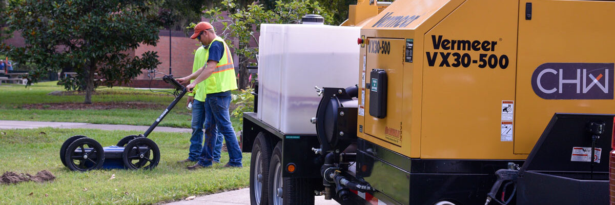
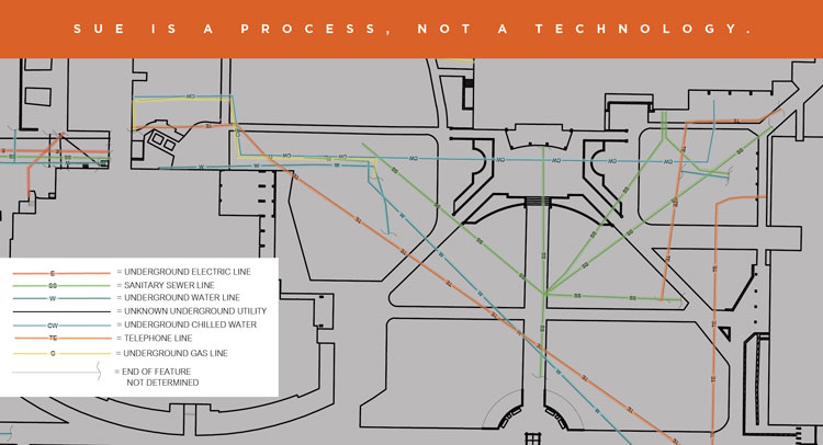
CHW’s Subsurface Utility Engineering (SUE) crew worked with Moses Engineering to create survey limits based on the proposed corridor for the upgraded Chilled Water line. Our final survey provided quality level “B” locations of existing utilities to ensure clearance to route the larger Chilled Water Pipes.

University of Florida Campus Gainesville, Fl

University of Florida

The CHW Surveying + Mapping team partnered with the University of Florida and RMF Engineering to support the Chilled Water expansion and improvements throughout the UF campus in Gainesville, Florida.

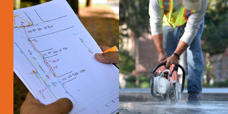
CHW’s Quality Level “D” and “B” utility maps assisted in designing these Chilled Water upgrades. To ensure no existing utilities crossed at the proposed locations, we Verified the Vertical and Horizontal positions (VVH), Quality Level “A,” from the west end of the UF Reitz Union, down the entire length of Inner Road, across SW 13th Street, to Norman Hall.

CHW’s Subsurface Utility Engineering (SUE) crew determined if any existing utilities would conflict with proposed traffic signal mast arms through non-destructive exploratory digs using vacuum excavation at two corners of SW 13th Street and Inner Road.

Benefits of SUE

You can see our passion for improving infrastructure through the projects we provide professional services for in the communities we serve. The Subsurface Utility Mapping we completed in the City of Gainesville at the University of Florida assisted in the design and upgrades for the Chilled Water Production on campus. The UF Chilled Water Production is responsible for 10 chilled water plants, housing 36 water-cooled chillers, totaling 47,000 tons of cooling capacity.

Utility Mapping can reduce risks and save money. A Purdue University study commissioned by the Federal Highway Administration (FHWA) found a savings of $4.62 on project costs for every $1.00 spent on SUE services!

If you are in need of SUE support services, or just want to discuss SUE support services, contact CHW’s expert Surveyors at marketing@chw-inc.comOur goal is to apply our surface and subsurface mapping skills to improve our client’s bottom lines and reduce risk.

Subsurface Utility Engineering Utility Mapping in Florida

Fill out the form below to download the handbook.

Form #1 - Redirection to PDF

Form #2 - Sends email containing the link to the PDF

"*" indicates required fields

This field is for validation purposes and should be left unchanged.

eNewsletter - NV5 Real Estate Transaction Services

Contact NV5 Real Estate Transaction Services

Download NV5 2022 Compliance Calendar

Please fill out the form below. After successful form submission, you will be redirected to the requested file. Thank you.

"*" indicates required fields

This field is for validation purposes and should be left unchanged.
We are an equal opportunity employer. All applicants will be considered for employment without attention to race, color, religion, sex, sexual orientation, gender identity, national origin, veteran or disability status. We ensure nondiscrimination in all programs and activities in accordance with Title VI of the United States Civil Rights Act of 1964. If you need more information or special assistance for persons with disabilities or limited English proficiency, contact MaryJo OBrien at (954) 495-2112. Persons with hearing-and speech-impairments can contact the NV5 by using the Virginia Relay Service, a toll-free telecommunication device for the deaf (TDD). Call 711 for TTY/TDD.
This field is hidden when viewing the form

Hyperspectral Imaging - Technically Speaking

Our internal innovation and development team constantly analyzes new technology and develops solutions to meet our client’s challenges. Our Technically Speaking series is one way we share our technical findings with the professional community. 

Please tell us a little about yourself by filling out the form below, and we’ll share the document with you, thanks!

Accuracy Part 1- Technically Speaking

Our internal innovation and development team constantly analyzes new technology and develops solutions to meet our client’s challenges. Our Technically Speaking series is one way we share our technical findings with the professional community. 

Please tell us a little about yourself by filling out the form below, and we’ll share the document with you, thanks!

Prune Optimization Webinar Recording

NV5 Geospatial releases a new predictive modeling platform for vegetation management that uses existing lidar and historical data to identify the relative level of asset risk from trees by quantifying the potential for causing asset damage. 

Please tell us a little about yourself by filling out the form below, and we’ll share the document with you, thanks!

Topobathy Lidar - Technically Speaking

Our internal innovation and development team constantly analyzes new technology and develops solutions to meet our client’s challenges. Our Technically Speaking series is one way we share our technical findings with the professional community. 

Please tell us a little about yourself by filling out the form below, and we’ll share the document with you, thanks!

Contact Geospatial

Contact Geospatial