KBC Advisors, a fast-moving full-service real estate advisory firm, relies on ArcGIS Enterprise to deliver location-driven insights to its national network of brokers and clients. With workflows built around high-frequency parcel updates and web-based applications, GIS availability and performance are non-negotiable. Downtime or lag not only slows decision-making, it impacts client trust.
As the firm expanded its use of GIS and added new applications, it needed a better way to stay ahead of potential system issues. That’s where NV5 and ArcGIS Monitor 2023 came in.
Solution
NV5 had been evaluating the new ArcGIS Monitor 2023 platform for use across its managed services clients. Known for being early adopters and collaborative partners, KBC Advisors agreed to let NV5 conduct performance monitoring tests in their environment. That pilot quickly became a long-term solution.
ArcGIS Monitor 2023 provides KBC and NV5 with a centralized dashboard to continuously track system health and performance across KBC’s AWS-hosted ArcGIS Enterprise deployment. With built-in thresholds, NV5 is alerted before disk space, CPU, or memory usage becomes critical, allowing them to proactively tune environments and scale resources.
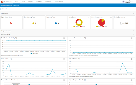
A screenshot of the home screen, currently set to show the Production collection.
“Monitor gives us a window into system performance we just didn’t have before,” said Tamara Dunbarr, Senior Geospatial Cloud Solutions Engineer at NV5. “It’s more than just infrastructure metrics. We can track feature service responsiveness, monitor portal content usage, and even guide decisions about what to retire or upgrade.”
For KBC, this level of visibility proved especially important when processing large geospatial data updates that support their internal applications. “Our internal parcel and spatial data services, along with other custom layers, are used within hundreds of custom Esri applications to support internal workflows. Ensuring we can serve up accurate data without system delays is key to making pitches and client presentations run smoothly,” said James Drumm, Director, Services & Technology at KBC. With Monitor, NV5 could confirm database write operations were completed as expected and make real-time adjustments when CPU usage spiked during ETL jobs.
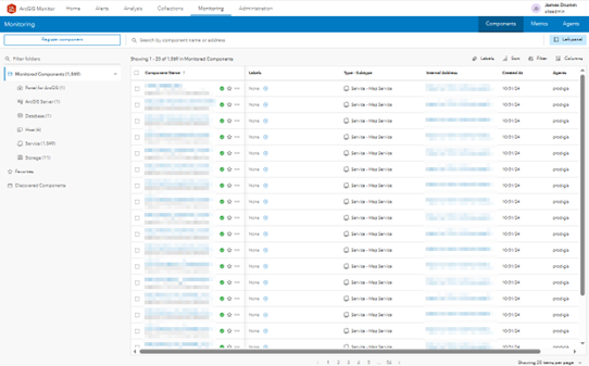
Monitoring screen displaying all tracked system components. On the left, you can see which components are being monitored, along with the number of subcomponents for each type. The high Service number reflects the monitor’s ability to track every published service within the enterprise environment.
Benefits
Increased uptime and faster recovery: Monitor alerts NV5 before performance impacts become critical, allowing preventative intervention.
Improved user experience: Real-time metrics help ensure that KBC’s map applications load quickly and reliably for clients.
Streamlined content management: NV5 is expanding Monitor usage to help KBC assess content freshness and user engagement, informing cleanup and optimization decisions.
Future-ready infrastructure: The insights gained are helping guide hardware scaling and application tuning as KBC’s GIS footprint grows.
A Partnership Built on Innovation
KBC Advisors is known for embracing the latest Esri technologies. From being early adopters of ArcGIS Monitor 2023 to quickly upgrading core Enterprise components, the firm has a track record of prioritizing performance and reliability. With NV5’s managed services team by their side, they’re not just reacting to GIS issues, they’re staying ahead of them.
“Monitoring isn’t just about avoiding downtime,” said Theron Hodel, Account Executive at NV5. “It’s about making sure every service performs at its peak, every time a client logs in.”
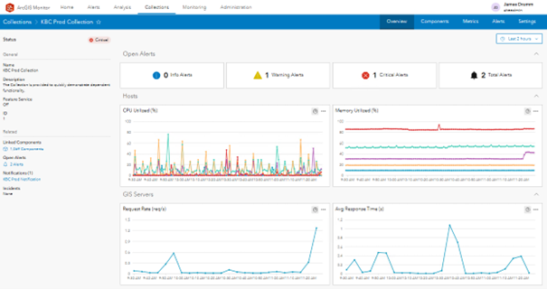
ArcGIS Collections screen showing the dashboard for the "Production" collection. Alert descriptions are displayed at the top, with key metrics presented below for quick status insight.
Looking Ahead
As NV5 continues to manage KBC’s GIS environment under a multi-year engagement, new opportunities to expand Monitor’s role are already on the horizon including advanced user tracking, content lifecycle management, and support for proactive planning and budgeting.
KBC’s story demonstrates how targeted system monitoring with ArcGIS Monitor can elevate GIS operations from reactive support to proactive performance optimization.
About NV5 Geospatial- NV5 Geospatial is a provider of geospatial services, providing end-to-end solutions and insights to organizations that need geospatial intelligence to mitigate risk, plan for growth, better manage resources and advance scientific understanding. We combine the widest array of advanced remote sensing technologies with proprietary processes, analytics tools, algorithms, and analyses tailored to meet our clients’ needs.
Form #2 - Sends email containing the link to the PDF
"*" indicates required fields
eNewsletter - NV5 Real Estate Transaction Services
Contact NV5 Real Estate Transaction Services
Download NV5 2022 Compliance Calendar
Please fill out the form below. After successful form submission, you will be redirected to the requested file. Thank you.
"*" indicates required fields
Hyperspectral Imaging - Technically Speaking
Our internal innovation and development team constantly analyzes new technology and develops solutions to meet our client’s challenges. Our Technically Speaking series is one way we share our technical findings with the professional community.
Please tell us a little about yourself by filling out the form below, and we’ll share the document with you, thanks!
Accuracy Part 1- Technically Speaking
Our internal innovation and development team constantly analyzes new technology and develops solutions to meet our client’s challenges. Our Technically Speaking series is one way we share our technical findings with the professional community.
Please tell us a little about yourself by filling out the form below, and we’ll share the document with you, thanks!
Prune Optimization Webinar Recording
NV5 Geospatial releases a new predictive modeling platform for vegetation management that uses existing lidar and historical data to identify the relative level of asset risk from trees by quantifying the potential for causing asset damage.
Please tell us a little about yourself by filling out the form below, and we’ll share the document with you, thanks!
Topobathy Lidar - Technically Speaking
Our internal innovation and development team constantly analyzes new technology and develops solutions to meet our client’s challenges. Our Technically Speaking series is one way we share our technical findings with the professional community.
Please tell us a little about yourself by filling out the form below, and we’ll share the document with you, thanks!