Monitor, Measure & Mitigate: Integrated Solutions for Geohazard Risk

Helping Infrastructure, Transportation and Utility Leaders Stay Ahead of Landslides, Subsidence, and Slope Failures

Geohazards such as slope instability, erosion, settlement, or seepage pose ongoing risks to critical infrastructure. Roads, railways, pipelines, and utility corridors are especially vulnerable to these natural and human-influenced processes, which can evolve silently until sudden failure occurs. Traditional ground surveys provide only periodic snapshots, leaving blind spots in between inspections. That is where NV5’s integrated approach makes the difference.

As satellite imagery and Synthetic Aperture Radar (SAR) technology advance with higher revisit rates and improved resolution, the opportunities for continuous geohazard monitoring have never been greater. NV5 has built on this momentum, combining automated tipping and cuing systems with 30+ years of engineering expertise to deliver comprehensive geohazard monitoring, measurement, and mitigation solutions to prevent costly damage and catastrophic failures.

Monitor: Proactive Detection Through Remote Sensing

Terrestrial Limitations Meet Satellite Advantage

Traditional ground surveys, especially over hundreds of miles of spatially dispersed assets like roads, railways, or landslide-prone corridors, require extensive time and resources and still often fail to identify evolving threats between surveys. SAR-based monitoring with ENVI Inform, NV5’s automated monitoring system that analyzes large volumes of data and delivers insights, fills those gaps with near real time detection of abnormal movement.

  • Baseline Creation: We build a detailed historical record, filtering through archived SAR data to create a geospatial baseline of asset movement patterns over the past decade.
  • Routine Surveillance Cadence: With revisit times as frequent as 11 days, ENVI Inform can detect movement in near-real time. This information can be used to assess if movements are expected or abnormal.
  • Tipping and Cueing Alerts: Automated alerts flag areas showing anomalous behavior, serving as a high-resolution early warning system for potential geohazard development.
Image 1. This ENVI Inform dashboard shows InSAR-based monitoring of rail infrastructure. Automated analysis highlights areas of ground displacement (in red) with an 84.5 percent confidence level, providing early warning for potential geohazard risks and supporting targeted field Inspection.

Measure: Ground Truthing the Alerts

Remote Intelligence Backed by Engineering Rigor

Once SAR-based monitoring is used to identify potential issues, our engineers and surveyors investigate using ground-based instrumentation. We can confirm settlement, slope stability, subsidence, and other potential hazards.

  • Subsurface Exploration: When warranted, we can use subsurface drilling, geologic site reconnaissance, geophysics, or other methods within areas of interest and assess geotechnical site conditions.
  • Additional instrumentation to understand site conditions can be installed. These may include slope inclinometers, TDR (Time Domain Reflectometry) cables, groundwater piezometers, crack gauges, settlement monuments, and others to better understand site conditions and whether they are stable or changing.
  • Contextual Interpretation: Our experts interpret data within the geological context, site history, weather history, and other information to identify causes.
Image 2. NV5 engineers validate satellite-based alerts with on-site geotechnical investigations, combining field measurements with decades of engineering expertise to understand ground conditions and ensure reliable mitigation strategies.

Mitigate: Engineering Solutions That Work

From Detection to Actionable Engineering

With prioritized high-risk areas identified, NV5’s engineering team steps in to deliver:

  • Comprehensive Remediation Designed: Tailored approaches such as grading, ground improvement, foundation underpinning/repair, retaining structures, drainage control, , erosion protection, or others, including asset relocation if feasible and most effective.
  • Cost-Effective Execution: Drawing on NV5’s dual expertise in surveying and engineering, we strive for mitigation strategies that balance safety, cost, and implementation speed.
  • End-to-End Responsibility: We don’t just hand off plans, NV5 supports clients through construction phase oversight and final validation.
Image 3. Engineered slope stabilization along a roadway corridor demonstrates NV5’s end-to-end approach to geohazard mitigation, from early detection to design and construction of durable, site-specific remediation solutions.

Lidar: Precision Change Detection and Terrain Analysis

While SAR offers powerful capabilities for large-scale monitoring, lidar remains one of the most effective tools for high-resolution terrain analysis, change detection, and volumetric measurement. NV5 integrates repeat lidar collections into its geohazard workflows to quantify subtle but critical changes in topography over time.

Baseline Terrain Models: Using bare-earth lidar data, NV5 builds precise baseline terrain models against which future collections can be compared. This allows us to identify both gradual and sudden changes in slope stability, settlement, or erosion features.

Change Detection and Volumetrics: By comparing lidar datasets across years or even seasons, NV5 calculates the extent and volume of earth movement. For example, lidar-based analysis can measure a slope failure’s areal growth, elevation changes, and total volume displaced, critical metrics for assessing hazard severity.

Before and after lidar views of the Oso Landslide in Washington. Vegetation is classified and colorized by height, with darker greens representing taller vegetation. The comparisons highlight the dramatic displacement of material and loss of vegetation, underscoring how lidar datasets capture both pre-event conditions and post-event impacts with precision. 

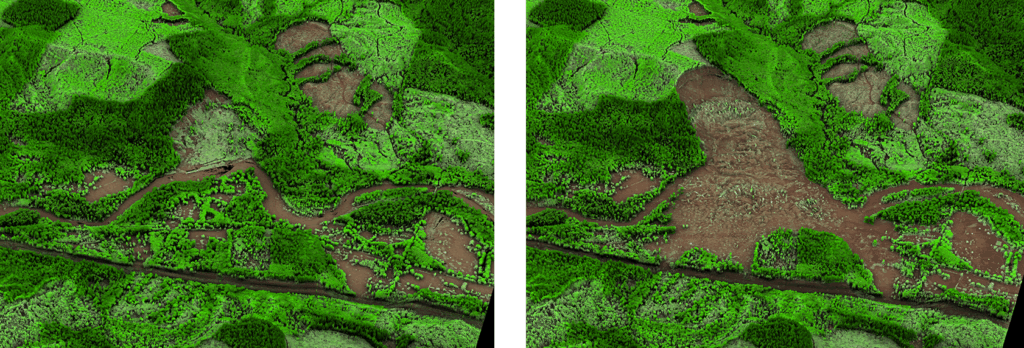
Erosion and Sedimentation Tracking: Lidar-derived morphology products (hillshades, slope maps, roughness indices) enable detection of subtle terrain failure and erosion patterns. These data are interpreted by Nv5’s geologists and engineers to understand causation, whether from natural processes or human activity like uphill development.

Target Mitigation Planning: With lidar, the appropriate level of precision depends on the scale of the problem you’re addressing. Broad-area collections at the county, state, municipal, or watershed level provide a valuable historic record and context for identifying emerging patterns of instability. But when the goal shifts to site-specific remediation, UAS-based lidar surveys deliver the centimeter-level precision needed to quantify displaced material, map future risk zones, and design effective mitigation strategies. By combining these scales, engineers can move from big-picture monitoring to detailed, actionable plans tailored to high-risk area.

Smarter, Unified Geohazard Management

By combining SAR-base wide area surveillance with lidar’s precision measurement capabilities, NV5 delivers a multi-scale approach to geohazard monitoring. This allows infrastructure, transportation and utility leaders to detect emerging issues early, measure their scope with accuracy, and take timely, informed action before problems escalate.

Unlike traditional approaches that require juggling multiple vendors for satellite analysis, surveying and engineering, NV5 offers a true end-to-end solution. Our integrated workflows ensure continuity, accountability, and efficiency from first detection through remediation.

The NV5 Advantage:

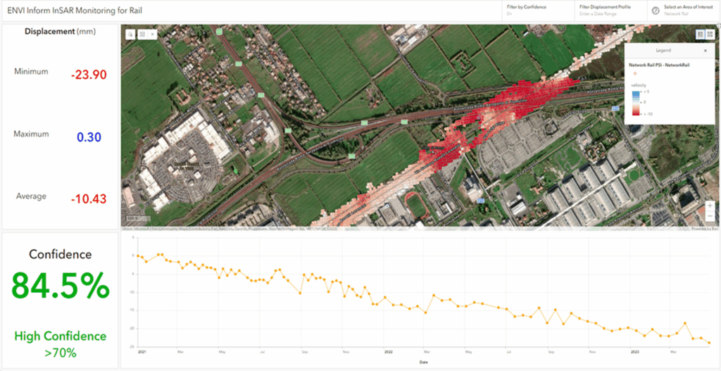
  • Pre-emptive satellite-based monitoring
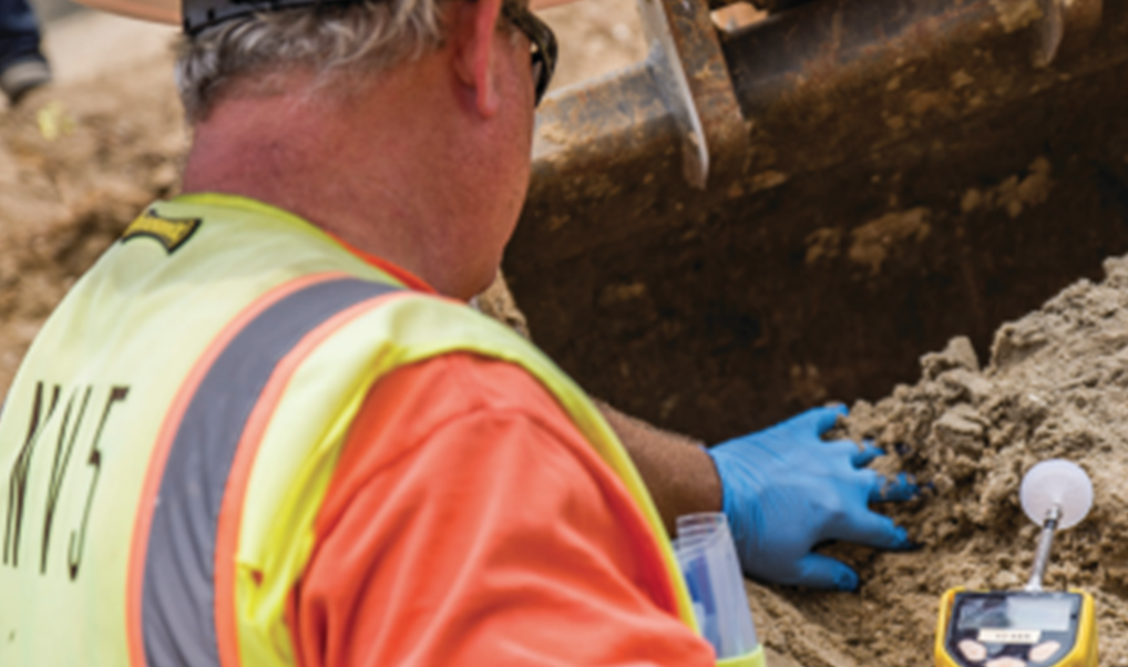
  • Seamless ground-based validation by engineers
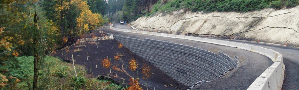
  • Turnkey mitigation planning and execution

If you manage critical assets and want to close the gaps in your geohazard management strategy, NV5 is ready to help. Reach out to our team at geospatialinfo@nv5.com

Let NV5 help you monitor smarter, measure accurately, and mitigate effectively. 

About NV5 Geospatial- NV5 Geospatial is a provider of geospatial services, providing end-to-end solutions and insights to organizations that need geospatial intelligence to mitigate risk, plan for growth, better manage resources and advance scientific understanding. We combine the widest array of advanced remote sensing technologies with proprietary processes, analytics tools, algorithms, and analyses tailored to meet our clients’ needs.

Fill out the form below to download the handbook.

Form #1 - Redirection to PDF

Form #2 - Sends email containing the link to the PDF

"*" indicates required fields

This field is for validation purposes and should be left unchanged.

eNewsletter - NV5 Real Estate Transaction Services

Contact NV5 Real Estate Transaction Services

Download NV5 2022 Compliance Calendar

Please fill out the form below. After successful form submission, you will be redirected to the requested file. Thank you.

"*" indicates required fields

We are an equal opportunity employer. All applicants will be considered for employment without attention to race, color, religion, sex, sexual orientation, gender identity, national origin, veteran or disability status. We ensure nondiscrimination in all programs and activities in accordance with Title VI of the United States Civil Rights Act of 1964. If you need more information or special assistance for persons with disabilities or limited English proficiency, contact MaryJo OBrien at (954) 495-2112. Persons with hearing-and speech-impairments can contact the NV5 by using the Virginia Relay Service, a toll-free telecommunication device for the deaf (TDD). Call 711 for TTY/TDD.
This field is hidden when viewing the form
This field is for validation purposes and should be left unchanged.

Hyperspectral Imaging - Technically Speaking

Our internal innovation and development team constantly analyzes new technology and develops solutions to meet our client’s challenges. Our Technically Speaking series is one way we share our technical findings with the professional community. 

Please tell us a little about yourself by filling out the form below, and we’ll share the document with you, thanks!

Accuracy Part 1- Technically Speaking

Our internal innovation and development team constantly analyzes new technology and develops solutions to meet our client’s challenges. Our Technically Speaking series is one way we share our technical findings with the professional community. 

Please tell us a little about yourself by filling out the form below, and we’ll share the document with you, thanks!

Prune Optimization Webinar Recording

NV5 Geospatial releases a new predictive modeling platform for vegetation management that uses existing lidar and historical data to identify the relative level of asset risk from trees by quantifying the potential for causing asset damage. 

Please tell us a little about yourself by filling out the form below, and we’ll share the document with you, thanks!

Topobathy Lidar - Technically Speaking

Our internal innovation and development team constantly analyzes new technology and develops solutions to meet our client’s challenges. Our Technically Speaking series is one way we share our technical findings with the professional community. 

Please tell us a little about yourself by filling out the form below, and we’ll share the document with you, thanks!

Contact Geospatial

Contact Geospatial