Search
Archives

Hidden Portland

(OR: WEIRD THINGS I’VE LEARNED BECAUSE OF MY JOB)

Before I came to work for NV5, my knowledge of Portland, Oregon, was limited to awesome places to eat and Powell’s Books. And that’s not a bad place to start, but there’s a lot more to Portland than meets the eye.

The 
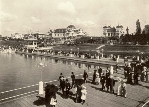
Lewis and Clark Exposition, 1905 - about the same amount of handlebar mustaches as modern PDX

I’ve learned a lot about the city our Pacific Northwest hub calls home through project research. This research informs how a geotechnical engineer or environmental consultant will approach a project site, and often, it unearths interesting things that I’m not even looking for. It’s like having a secret – knowing that you’re standing on what used to be a lake, or that the movie theater you’re sitting in used to be a world’s fair exhibit hall.

So, without further ado, enjoy some Hidden Portland trivia:

  • A creek runs under it: Tanner Creek used to run through the whole of downtown, emptying into Couch Lake (between the Steel and Fremont Bridges). Today, it’s mainly in a system of pipes that runs under Providence Park and out into the Willamette. Looking for the creek in present day Portland? Some say they can hear it rushing under a manhole cover near Providence Park, but few people today have seen it with their own eyes. Tanner Springs Park is now located where the creek used to flow, an homage to the wetlands that used to dominate the Pearl District.
  • Portland’s (only) world’s fair: The Lewis & Clark Centennial Exposition was in 1905, taking place around the edges of what used to be Guild’s Lake. Planners built a majestic, temporary city in what is now NW Portland. The lake itself was eventually filled, and the buildings either torn down, moved, or (tragically, in the case of the beautiful forestry building) succumbed to fire. For a brief history and some incredible photos of a completely erased section of Portland, check out this article from the Oregonian.
  • Speaking of Guild’s Lake, someone tried to fill it in without permission: Former congressman Lafe Pence saw Guild’s Lake as prime real estate for an industrial district, so he built flumes into the west hills and sluiced huge volumes of soil into the lake – without a right of way permit. As you can imagine, this went over well, and at one point the mayor actually sent police with axes to destroy one of the flumes. Eventually, however, the filling of Guild’s Lake was completed (without Pence), and became the industrial district he envisioned – just without any personal gain on his part.
  • The street grid used to be a postal carrier’s nightmare: In “1891, there were twelve ‘A’ streets, twelve ‘B’ streets, twelve ‘First’ streets, nine ‘Cedar’ streets and so on,” according to Eugene E. Snyder, in “Portland Names and Neighborhoods: Their Historic Origins.” Why? After incorporating St. Johns, East Portland, and Albina, Portland found itself with a confusing network of duplicate street names. How long did it take for this to be rectified? It’s a long story, but basically, until 1931. Interesting side-effect: rumor has it there are older sections of sidewalk that still have these original street names stamped into them. I haven’t been able to find one yet, but I’m always looking for sidewalks that don’t match their street signs. And now you will too. You’re welcome – and happy hunting.

I’ve learned a lot about the city our Pacific Northwest hub calls home through project research. This research informs how a geotechnical engineer or environmental consultant will approach a project site, and often, it unearths interesting things that I’m not even looking for. It’s like having a secret – knowing that you’re standing on what used to be a lake, or that the movie theater you’re sitting in used to be a world’s fair exhibit hall.

Check out our gallery below for additional pictures of historic Portland – all images public domain, obtained from https://commons.wikimedia.org/.

 Article by: Sarah Kelley


Gallery

Fill out the form below to download the handbook.

Form #1 - Redirection to PDF

Form #2 - Sends email containing the link to the PDF

"*" indicates required fields

This field is for validation purposes and should be left unchanged.

eNewsletter - NV5 Real Estate Transaction Services

Contact NV5 Real Estate Transaction Services

Download NV5 2022 Compliance Calendar

Please fill out the form below. After successful form submission, you will be redirected to the requested file. Thank you.

"*" indicates required fields

This field is for validation purposes and should be left unchanged.
We are an equal opportunity employer. All applicants will be considered for employment without attention to race, color, religion, sex, sexual orientation, gender identity, national origin, veteran or disability status. We ensure nondiscrimination in all programs and activities in accordance with Title VI of the United States Civil Rights Act of 1964. If you need more information or special assistance for persons with disabilities or limited English proficiency, contact MaryJo OBrien at (954) 495-2112. Persons with hearing-and speech-impairments can contact the NV5 by using the Virginia Relay Service, a toll-free telecommunication device for the deaf (TDD). Call 711 for TTY/TDD.
This field is hidden when viewing the form

Hyperspectral Imaging - Technically Speaking

Our internal innovation and development team constantly analyzes new technology and develops solutions to meet our client’s challenges. Our Technically Speaking series is one way we share our technical findings with the professional community. 

Please tell us a little about yourself by filling out the form below, and we’ll share the document with you, thanks!

Accuracy Part 1- Technically Speaking

Our internal innovation and development team constantly analyzes new technology and develops solutions to meet our client’s challenges. Our Technically Speaking series is one way we share our technical findings with the professional community. 

Please tell us a little about yourself by filling out the form below, and we’ll share the document with you, thanks!

Prune Optimization Webinar Recording

NV5 Geospatial releases a new predictive modeling platform for vegetation management that uses existing lidar and historical data to identify the relative level of asset risk from trees by quantifying the potential for causing asset damage. 

Please tell us a little about yourself by filling out the form below, and we’ll share the document with you, thanks!

Topobathy Lidar - Technically Speaking

Our internal innovation and development team constantly analyzes new technology and develops solutions to meet our client’s challenges. Our Technically Speaking series is one way we share our technical findings with the professional community. 

Please tell us a little about yourself by filling out the form below, and we’ll share the document with you, thanks!

Contact Geospatial

Contact Geospatial