Assessing the Threshold: What Remote Sensing Accuracy is “Good Enough”?
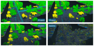
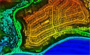
In the remote sensing industry, we’re observing a growing market demand for lower-cost, lower-resolution solutions. This raises a critical question: what level of accuracy is
In the remote sensing industry, we’re observing a growing market demand for lower-cost, lower-resolution solutions. This raises a critical question: what level of accuracy is
Challenge KBC Advisors, a fast-moving full-service real estate advisory firm, relies on ArcGIS Enterprise to deliver location-driven insights to its national network of brokers and

View our June edition to learn about our latest geospatial projects. CLICK HERE. June Newsletter

Executive Summary When the world’s busiest airport needed to modernize its GIS and asset management capabilities, NV5 delivered. Through a multi-agency partnership with the City
Empowering public access, flexibility, and cost savings through a modern viewing platform The Commonwealth of Kentucky has launched a groundbreaking new Nadir and Oblique Statewide

View our May edition to learn about our latest geospatial projects. CLICK HERE. May Newsletter

View our April edition to learn about our latest geospatial projects. CLICK HERE. April Newsletter Read the latest stories on what’s new with NV5’s geospatial

From Oracle to SQL for Enhanced Efficiency and Future Growth Boston Water and Sewer Commission (BWSC) manages the largest and oldest system of its kind
From Digital Twins to Topobathy to AI: NV5 Experts Present Game-Changing Applications for Environmental and Infrastructure Monitoring HOLLYWOOD, Fla., February 5, 2025 – NV5, the world’s
Lidar data collected by NV5 can help quantify fire damage, identify areas at risk of debris flows or flooding, and guide restoration efforts. LOS ANGELES,