The Path to Smarter, Connected Asset Management
Organizations everywhere are working toward AI-driven operations, but legacy and on-prem systems often stand in the way. Trimble Unity changes that. It’s not just another
Organizations everywhere are working toward AI-driven operations, but legacy and on-prem systems often stand in the way. Trimble Unity changes that. It’s not just another

Helping Infrastructure, Transportation and Utility Leaders Stay Ahead of Landslides, Subsidence, and Slope Failures Geohazards such as slope instability, erosion, settlement, or seepage pose ongoing
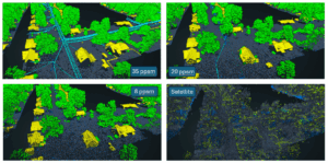
In the remote sensing industry, we’re observing a growing market demand for lower-cost, lower-resolution solutions. This raises a critical question: what level of accuracy is
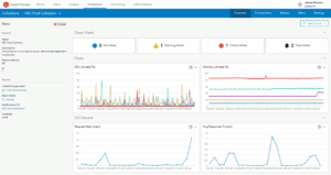
Challenge KBC Advisors, a fast-moving full-service real estate advisory firm, relies on ArcGIS Enterprise to deliver location-driven insights to its national network of brokers and

View our June edition to learn about our latest geospatial projects. CLICK HERE. June Newsletter

Executive Summary When the world’s busiest airport needed to modernize its GIS and asset management capabilities, NV5 delivered. Through a multi-agency partnership with the City

View our May edition to learn about our latest geospatial projects. CLICK HERE. May Newsletter

In today’s rapidly evolving technological landscape, organizations are constantly seeking innovative ways to harness the power of data and artificial intelligence (AI) to drive efficiency,

View our April edition to learn about our latest geospatial projects. CLICK HERE. April Newsletter Read the latest stories on what’s new with NV5’s geospatial
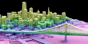
From Digital Twins to Topobathy to AI: NV5 Experts Present Game-Changing Applications for Environmental and Infrastructure Monitoring HOLLYWOOD, Fla., February 5, 2025 – NV5, the world’s