Assessing the Threshold: What Remote Sensing Accuracy is “Good Enough”?
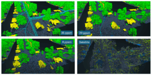
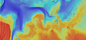
In the remote sensing industry, we’re observing a growing market demand for lower-cost, lower-resolution solutions. This raises a critical question: what level of accuracy is
In the remote sensing industry, we’re observing a growing market demand for lower-cost, lower-resolution solutions. This raises a critical question: what level of accuracy is
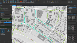
Challenge KBC Advisors, a fast-moving full-service real estate advisory firm, relies on ArcGIS Enterprise to deliver location-driven insights to its national network of brokers and

View our June edition to learn about our latest geospatial projects. CLICK HERE. June Newsletter

Executive Summary When the world’s busiest airport needed to modernize its GIS and asset management capabilities, NV5 delivered. Through a multi-agency partnership with the City

View our May edition to learn about our latest geospatial projects. CLICK HERE. May Newsletter

View our April edition to learn about our latest geospatial projects. CLICK HERE. April Newsletter Read the latest stories on what’s new with NV5’s geospatial
From Digital Twins to Topobathy to AI: NV5 Experts Present Game-Changing Applications for Environmental and Infrastructure Monitoring HOLLYWOOD, Fla., February 5, 2025 – NV5, the world’s
Leading Geospatial Firm to Present Innovations in SAR Analytics, AI-Powered Large Language Models and Coastal Surveying Solutions that Leverage Topobathymetry to Connect Land and Sea
New Hydrographic Survey in Lake Michigan Among Projects Using Cutting-edge Survey Technologies and Creative Approaches to Yield Actionable Data that Supports Maritime Mapping, Resource Management
HOLLYWOOD, Fla. — NV5, a global leader providing geospatial solutions, services, and software to solve mission critical challenges, today announced it has earned requalification in