
IT Service Specialist
Quantum Spatial is hiring a service specialist to provide first-rate IT support in a friendly, helpful way that builds trust and education, ensuring our teams

Quantum Spatial is hiring a service specialist to provide first-rate IT support in a friendly, helpful way that builds trust and education, ensuring our teams

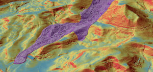
The cover story of the October issue of LiDAR News features Quantum Spatial’s breakthrough solutions regarding landslide mitigation efforts, and how the results generate a

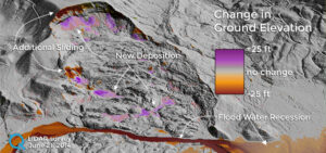
The devastating landslide of Oso, Washington, which claimed the lives of 43 people on March 22, 2014, continues to alter the landscape. Quantum Spatial conducted

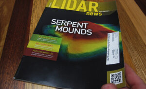
As seen on the Discovery Channel and featured in LiDAR News, Quantum Spatial assisted an archeological and anthropological investigation of ancient mounds by employing our aerial, terrestrial, and

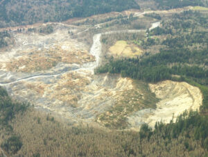
Landslides are a major geologic hazard. As urban and recreational development expands into hillside areas, more and more people and critical infrastructure—including power lines, roads
Fill out the form below to download the handbook.
"*" indicates required fields
Please fill out the form below. After successful form submission, you will be redirected to the requested file. Thank you.
"*" indicates required fields
Our internal innovation and development team constantly analyzes new technology and develops solutions to meet our client’s challenges. Our Technically Speaking series is one way we share our technical findings with the professional community.
Please tell us a little about yourself by filling out the form below, and we’ll share the document with you, thanks!
NV5 Geospatial releases a new predictive modeling platform for vegetation management that uses existing lidar and historical data to identify the relative level of asset risk from trees by quantifying the potential for causing asset damage.
Please tell us a little about yourself by filling out the form below, and we’ll share the document with you, thanks!
Our internal innovation and development team constantly analyzes new technology and develops solutions to meet our client’s challenges. Our Technically Speaking series is one way we share our technical findings with the professional community.
Please tell us a little about yourself by filling out the form below, and we’ll share the document with you, thanks!