
NV5 Geospatial’s Michael Shillenn Elected to MAPPS Board of Directors
Michael B. Shillenn,CP, ASPRS senior account manager for NV5 Geospatial has been elected to serve on the board of MAPPS, the preeminent national association of
Michael B. Shillenn,CP, ASPRS senior account manager for NV5 Geospatial has been elected to serve on the board of MAPPS, the preeminent national association of
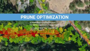
Prune Optimization – Wednesday, August 25th @ 2 PM ET. Access Recording NV5 Geospatial, powered by Quantum Spatial, North America’s largest geospatial data firm, today announced

The NV5 Geospatial Anchorage office focuses on conducting environmentally responsible and sustainable projects across Alaska that help us adapt to a changing landscape and climate

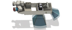
Lidar technology continues to advance, both in terms of sensor hardware and platform deployment. NV5 Geospatial and Oklahoma Department of Transportation performed a series of tests
NV5 Geospatial, powered by Quantum Spatial, North America’s largest geospatial data firm, has dramatically expanded its Canadian operations in 2020, having been selected to provide lidar,
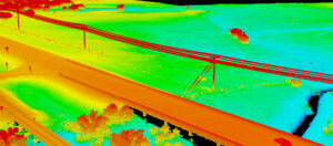
Keeping transportation projects on time and on budget can be a challenge for numerous reasons. But inaccurate mapping shouldn’t be one of them. NV5 Geospatial’s

HOLLYWOOD, FLA. (PRWEB) OCTOBER 21, 2020 Quantum Spatial, Inc., an NV5 company and North America’s largest geospatial data firm, recently completed the collection of topographic and
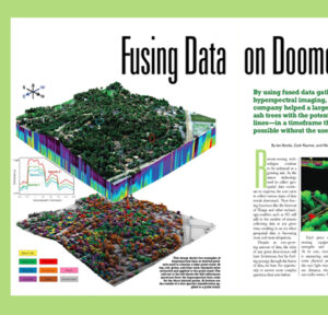
The emerald ash borer is decimating the ash trees across the nation, leading to large quantities of unhealthy and dead trees. In the presence of

Ron Chappel, founder and CEO of GEO1, has distinguished himself as a leader in aerial remote sensing acquisition. In the latest issue of Lidar Magazine, Jeff Winke
Quantum Spatial, Inc., an NV5 company, and the nation’s largest independent geospatial data firm, today announced its new sensor platform, which is designed to improve