
We love Alaska! Caitlin shares her Anchorage experience
Starting on August 25, Caitlin is hosting I Love Anchorage’s instagram feed for a week. Follow along to glimpse snapshots of her daily routine on and off
Starting on August 25, Caitlin is hosting I Love Anchorage’s instagram feed for a week. Follow along to glimpse snapshots of her daily routine on and off
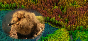
It’s so exciting to see Quantum Spatial’s LiDAR data come to fruition in helping wildlife biologists and forest managers better understand coastal old-growth canopy structure
In just a few days Quantum Spatial will land in Fort Worth, Texas for the International Society of Arboriculture Conference and Trade Show (ISA). We will be

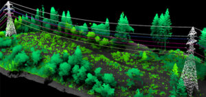
Aerial MOB, LLC, a leader in UAS (drone) aerial technology applications, has reached a strategic partnership agreement with Quantum Spatial Inc. (QSI), a leading supplier
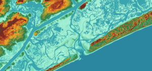
The NOAA Sandy Supplemental Sandy Topobathy LiDAR and Imagery project was recognized has been recognized with the LCDR Peter Johnson Best Practices Award at the
Quantum Spatial collected and analyzed LiDAR data for Utah’s Automated Geographic Reference Center. Government officials and researchers are using the LiDAR datasets in applications ranging

Quantum Spatial is hiring a service specialist to provide first-rate IT support in a friendly, helpful way that builds trust and education, ensuring our teams
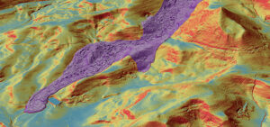
The cover story of the October issue of LiDAR News features Quantum Spatial’s breakthrough solutions regarding landslide mitigation efforts, and how the results generate a
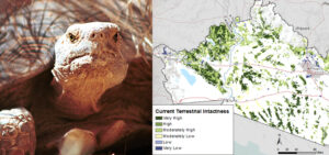
What is the REA program? Managed by the BLM, the Rapid Ecoregional Assessment (REA) program integrates varied datasets in order to evaluate ecosystem dynamics, habitat
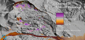
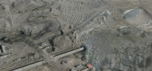
The devastating landslide of Oso, Washington, which claimed the lives of 43 people on March 22, 2014, continues to alter the landscape. Quantum Spatial conducted