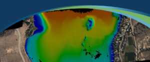
Addressing Change in Coastal Environments with Advanced Topobathymetric Elevation Modelling
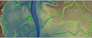
The Hydrospatial Data Collection Approach in Morro Bay – By Steve Raber, Ann Kitajima, Carolyn Geraghty Morro Bay, a shallow coastal estuary located near San
The Hydrospatial Data Collection Approach in Morro Bay – By Steve Raber, Ann Kitajima, Carolyn Geraghty Morro Bay, a shallow coastal estuary located near San

Projects include work with NOAA, USGS, Alaska Railroad Corporation, Alaska Department of Natural Resources, U.S. Fish and Wildlife and the U.S. Department of Agriculture ANCHORAGE,
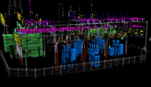
Use of robots equipped with sensors and cameras are helping to automate and improve maintenance of utilities. Ian Berdie, VP of Innovation for NV5 Geospatial,
Over the past three decades, thermal infrared technology has spread into a wide range of industries with varied applications including: monitoring river temperatures to promote
NV5 Geospatial’s Andrew Brenner and Cathy Power present at the Americaon Water Resources Association spring conference.
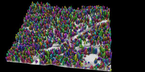
Success in Yosemite is driving the wider use of lidar surveys to support forest health and wildfire resilience, study wildlife habitats, and monitor water resources.

NV5 Geospatial and Geodynamics LLC, an NV5 company, experts Kurt Allen, Sloan Freeman, and Rudi Rudolph, hit The American Shoreline Podcast airwaves on Coastal News

INSITE Data Reviewer provides reviewers real-time access to aerial imagery, lidar data, GIS layers, and more via the cloud to standardize quality control. This increases data validation speed and reduces the costs of geospatial projects.
Tim Saultz brings with him more than three decades of experience managing strategic programs at scale with the USGS Hollywood, Florida – 04/05/2022 – NV5
Sven Cowan, NV5 Geospatial’s Canada Program Manager, details the recent topobathy lidar project of Okanagan Basin, British Columbia, Canada in the latest issue of GoGeomatics