
INSITE Lifecycle- Bringing your geospatial data full circle
Register Here NV5 Geospatial’s INSITE LIFECYCLE combines project tracking with data quality assurance and control. Providing instant access to geospatial data allows for a collaborative
Register Here NV5 Geospatial’s INSITE LIFECYCLE combines project tracking with data quality assurance and control. Providing instant access to geospatial data allows for a collaborative
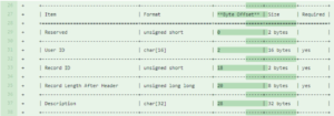
Evon Silvia, solutions architect with NV5 Geospatial, is chair of the ASPRS LAS Working Group. Dedicated to the development and standardization of lidar data, Evon
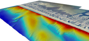
With the recent acquisition of Geodynamics LLC, NV5 Geospatial has built one of the most comprehensive suites of solutions for geospatial surveys of deep water and
Sven Cowan, Canada Program Manager for NV5 Geospatial, discusses the capabilities of INSITE Project Tracker a cloud-based data application for Go Geomatics Canada. The INSITE
Listen The UAV Podcast discusses how drones and other autonomous vehicles are deployed with lidar sensors to create 3D mapping data and downstream
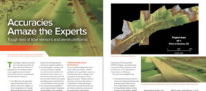
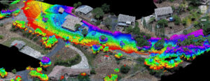
Lidar technology continues to advance, both in terms of sensor hardware and platform deployment. NV5 Geospatial and Oklahoma Department of Transportation performed a series of tests
NV5 Geospatial, powered by Quantum Spatial, North America’s largest geospatial data firm, has dramatically expanded its Canadian operations in 2020, having been selected to provide lidar,
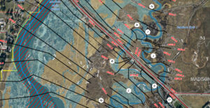
Keeping transportation projects on time and on budget can be a challenge for numerous reasons. But inaccurate mapping shouldn’t be one of them. NV5 Geospatial’s
HOLLYWOOD, FLA. (PRWEB) OCTOBER 21, 2020 Quantum Spatial, Inc., an NV5 company and North America’s largest geospatial data firm, recently completed the collection of topographic and