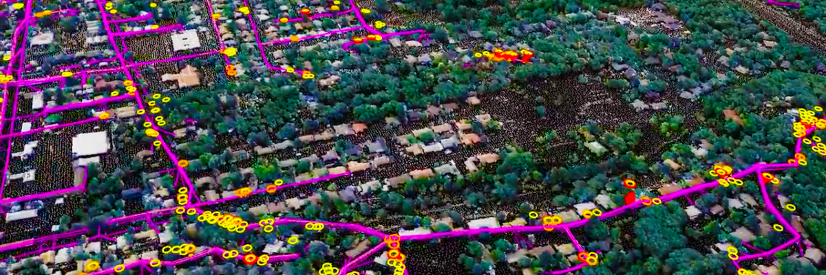
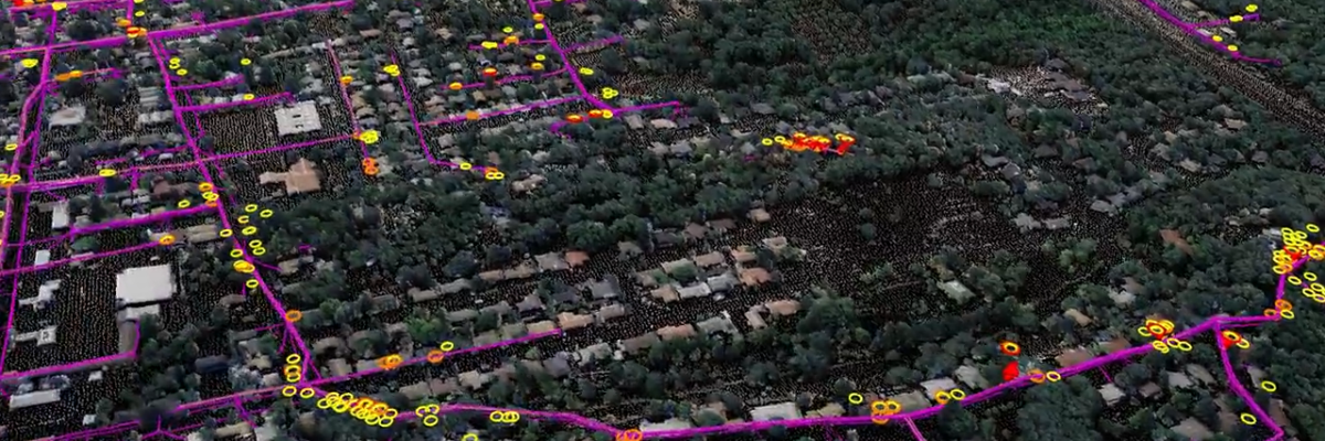
Asset and Vegetation Management Applications Help Utilities Minimize Risk and Improve Reliability of Electric Utilities NV5 Geospatial Uses Remote Sensing for UtilitiesGeospatial data firm NV5 Geospatial is applying remote-sensing data analysis to improve the way utilities manage their distribution networks. The company mapped more than 5.5 million miles of utility[...]
HOLLYWOOD, Fla., Feb. 16, 2023 (GLOBE NEWSWIRE) — NV5 Global, Inc. (the “Company” or “NV5”) (Nasdaq: NVEE), a provider of technology, conformity assessment, and consulting solutions, announced today that it has been awarded a $17 million contract to support the development of a detailed statewide aerial photography and elevation database[...]
Electric utilities are pivotal in providing electricity to residences and businesses in the U.S. However, the emerging labor shortage, rising energy consumption, and uncontrollable weather events, coupled with the aging grid, adversely affect electric utilities’ safety, customer service, and reliability. A boots-on-the ground approach to utility management is no longer[...]
Asset and Vegetation Management Applications Help Utilities Minimize Risk and Improve Reliability of Electric Distribution Network HOLLYWOOD, Fla., October 11, 2022 – NV5 Geospatial, North America’s most comprehensive geospatial data firm, is transforming the way utilities manage their distribution networks with remote sensing data analysis. Having mapped more than 5.5[...]
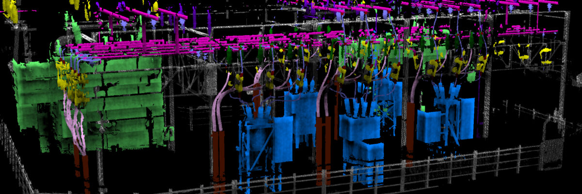
Use of robots equipped with sensors and cameras are helping to automate and improve maintenance of utilities. NV5 Geospatial, North America’s most comprehensive geospatial science data firm, today announced the debut of its ARIS II Rover. The upgraded robotic electric substation monitoring system comes after five years of in-field implementation[...]
Use of robots equipped with sensors and cameras are helping to automate and improve maintenance of utilities. Ian Berdie, VP of Innovation for NV5 Geospatial, discusses how robots equipped with remoted sensing technology are improving outcomes for utility substation management: As utilities strive for greater reliability and resilience, they turn[...]
Form #2 - Sends email containing the link to the PDF
"*" indicates required fields
eNewsletter - NV5 Real Estate Transaction Services
Contact NV5 Real Estate Transaction Services
Download NV5 2022 Compliance Calendar
Please fill out the form below. After successful form submission, you will be redirected to the requested file. Thank you.
"*" indicates required fields
Hyperspectral Imaging - Technically Speaking
Our internal innovation and development team constantly analyzes new technology and develops solutions to meet our client’s challenges. Our Technically Speaking series is one way we share our technical findings with the professional community.
Please tell us a little about yourself by filling out the form below, and we’ll share the document with you, thanks!
Accuracy Part 1- Technically Speaking
Our internal innovation and development team constantly analyzes new technology and develops solutions to meet our client’s challenges. Our Technically Speaking series is one way we share our technical findings with the professional community.
Please tell us a little about yourself by filling out the form below, and we’ll share the document with you, thanks!
Prune Optimization Webinar Recording
NV5 Geospatial releases a new predictive modeling platform for vegetation management that uses existing lidar and historical data to identify the relative level of asset risk from trees by quantifying the potential for causing asset damage.
Please tell us a little about yourself by filling out the form below, and we’ll share the document with you, thanks!
Topobathy Lidar - Technically Speaking
Our internal innovation and development team constantly analyzes new technology and develops solutions to meet our client’s challenges. Our Technically Speaking series is one way we share our technical findings with the professional community.
Please tell us a little about yourself by filling out the form below, and we’ll share the document with you, thanks!