
3D Hydrography Program
Discovering & Defining New Boundaries in Hydrography
3D Hydrography Program
Discovering & Defining New Boundaries in Hydrography
Grounded in Science
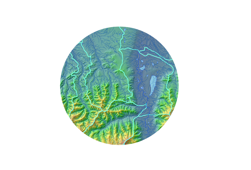
We provide a multi-environment process integrating multiple approaches to derive flowlines and hydrologic networks
We work with local experts to refine landscape-specific parameters for refinement and attribution of flowlines. We use a combination of flow direction and accumulation routines along with direct detection of landscape channelization through geomorphon analysis.
Setting the Standard
Our team has worked closely with the USGS Hydrography team on both the 3D Hydrography Program (3DHP) and the Watershed Boundary Dataset (WBD). This collaboration, in conjunction with our deep understanding of client needs and creative approach to solution development, has enabled us to develop new concepts and processes that support the increased complexity of 3DHP, meet specific needs of end users, and contribute to the next generation of hydrography data.
Collaborative Process
NV5 works side-by-side with our clients to balance their specific requirements with the USGS standards so that whatever investment is made in the development of 3DHP, it will progress the larger goal of a consistent nationwide network. NV5 will work with you to help develop your 3DHP plan and ensure that it meets your program’s long term needs the first time.
The NV5 Edge
• Performed USGS 3DHP pilots
• Developed 3DHP from IfSAR
• Developed the first NHD and WBD dataset from lidar that incorporated stormwater systems
• Actively supporting partnerships between local, state and federal agencies to promote 3DHP
• Advocate for USGS standards in 3DHP community
3DHP Project Map
READ OUR 3DHP BROCHURE
3DHP Brochure
Contact Us
NV5 Geospatial has been trusted to provide on-target geospatial solutions for roadways, airports, and all modes of rail infrastructure for decades. Our clients trust us because we’ve proven time and time again that we can find a better way to ensure the right solutions for their specific needs. In each case, we work with our transportation clients to select the appropriate platform, methodology, and analytics to maximize the value of our transportation GIS services
Planning
Coordinate the preliminary stages of a project including traffic studies, feasibility assessments, and an evaluation of potential environmental impacts for route alternatives. Planners, environmental scientists and engineers depend on our data and expertise to make decisions for corridor studies, route realignments, and road and bridge improvements. NV5 Geospatial has extensive experience supporting light rail, high speed rail, and interstate rail infrastructure as well as environmental assessments. Our services support the assessment and characterization of environmental conditions required for permitting applications. Solutions range from the provision of multispectral, hyperspectral, thermal, and lidar datasets, to traditional aerial photography, mapping and orthophotography.
Engineering
NV5 transportation GIS services consist large-scale mapping solutions, including low level/high accuracy lidar and low altitude photogrammetric mapping. From this data, NV5 Geospatial provides dense elevation point clouds, TINs, and mapping depicting closely spaced contours and detailed existing conditions. Mobile mapping can also be used to capture existing road, slope, ramp, and bridge abutment conditions. In addition, our high resolution orthophotography is considered by many engineers to be an indispensable design tool. With NV5 Geospatial in support, design teams are able to develop their construction documents with confidence.
Thermography for Bridge Decks
Thermal imaging identifies otherwise undetectable structural problems well before they reach the surface of bridge decks, and long before they can be seen during close range visual inspections.
Transport Clearance Analysis
NV5 Geospatial uses lidar to perform three-dimensional swept path clearance analysis for roads, bridges, tunnels, and other transportation infrastructure elements. Analysis is performed to determine if the oversize freight will be able to navigate a proposed route without conflict. These types of analysis are performed to validate as-built dimensions and support the Department of Transportation who assess routes using two dimensional drawings and cross sections.
Documentation
During construction – Track construction progress with a variety of our services such as periodic HD video, Orthophotography or Lidar. Conducted on a regular schedule, this monitors project status, analyzes problem areas and documents the completion of milestones for stakeholders and the public.
After construction – Create maps and 3D models of the as-built environment for reference files, GIS databases, or to help launch future engineering work. Imagery can be used for orthophotography and planimetric mapping while Lidar can be used for a variety of applications such as mapping final surface elevations and gradients, and extracting cross-section data sets. Mobile mapping systems can drive down the completed right-of-way and capture as-builts for the record.
eGIS
NV5 Geospatial’s GIS services offer a high degree of user functionality to help our clients manage their transportation corridors. These services include system analyses, development, design and updating. Components can include data capture and conversion, geodatabase modeling, document imaging and archiving solutions. On a recent project we created a project catalog system that provided single-click access to every dataset acquired during the project, giving the client management of all documentation from start to finish. Learn more about our eGIS capabilities.