Executive Summary
When the world’s busiest airport needed to modernize its GIS and asset management capabilities, NV5 delivered. Through a multi-agency partnership with the City of Atlanta, NV5 implemented a modern solution grounded in Trimble Unity Powered by Cityworks and ArcGIS Enterprise, integrated real-time data automation, and transitioned infrastructure to the cloud. The result? FAA compliance is now automated, interdepartmental workflows are aligned, and GIS is powering smarter decisions across the city.
Overview: Elevating Atlanta: From Target Support to Strategic Impact
What began as targeted GIS support evolved into a strategic citywide transformation. NV5 partnered with the City of Atlanta, supporting the Department of Aviation, Department of Transportation, and GIS teams, to roll out a modern asset management ecosystem centered around Hartsfield-Jackson Atlanta International Airport (HJAIA).
As the project scaled, it enabled digital workflows, improved operational visibility, and allowed departments to break down data silos. It now serves as a blueprint for future modernization across Atlanta’s public infrastructure.
The Challenge: Legacy Systems, Fragmented Data, and Regulatory Pressure
Before NV5 stepped in, many departments within the City of Atlanta relied on outdated technology. Their CMMS system, still in use, was costly to maintain and difficult to scale. GIS repositories were siloed across departments, and manual tracking created bottlenecks in workflows, especially when it came to FAA Part 139 compliance.
Critical questions emerged:
- How could the city move from reactive maintenance to predictive operations?
- Could real-time data improve public works responsiveness and aviation safety?
- Was there a smarter, scalable way to host GIS infrastructure?
Goals: Scalable Solutions for a Growing City
The City of Atlanta knew it needed more than a software upgrade. They needed a partner who could help them:
- Replace inefficient workflows with real-time, GIS-powered automation
- Migrate to a scalable cloud infrastructure to reduce costs
- Meet FAA compliance with greater speed and accuracy
- Improve cross-departmental coordination
- Set the stage for citywide expansion of asset management best practices
- Centralize information to support more informed decision-making
- Improve reporting capabilities and introduce a customer-facing service request portal
The NV5 Approach: Modernization in Action
To meet these goals, NV5 delivered an end-to-end strategy grounded in scalable technology and trusted collaboration.
Infrastructure & Software Modernization
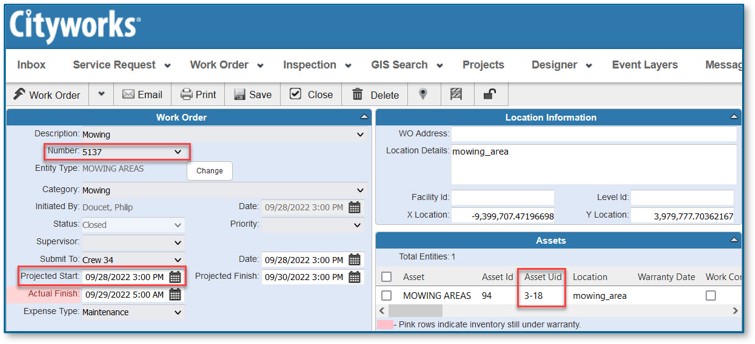
NV5 deployed ArcGIS Enterprise (including GeoEvent, QuickCapture, and Monitor) and Cityworks AMS to digitize asset and work order management across key departments. Legacy systems were migrated to a secure, Linux-based AWS cloud infrastructure, boosting performance while reducing hosting costs.
Real-Time Automation & FAA Compliance
Integrating tools like Samsara and FME, NV5 introduced real-time data feeds for asset tracking and automated inspection workflows. Tailored GIS solutions were developed specifically to meet FAA Part 139 compliance needs, streamlining both data capture and reporting.
Customer-Facing Service Request Portal
As part of the modernization effort, NV5 supported the integration of a customer-facing portal within Cityworks. This allowed for better capture and tracking of service requests, improving responsiveness and transparency for the public.
Collaborative Delivery & Training
From weekly stakeholder meetings to embedded staff and hands-on workshops, NV5 ensured smooth adoption. Staff were trained not just in how to use the tools, but how to think strategically with them.
“Our transition to Cityworks has been more than a system upgrade, it’s been a strategic partnership. NV5 has not only embraced our vision but empowered it, allowing us to design some of the most creative and complex workflows tailored to how we do business. Their guidance, insight, and expertise have been instrumental in turning ideas into actionable, effective solutions.”
— Shermaine Freeman, Interim Airport Assistant General Manager, Business Services, Hartsfield-Jackson Atlanta International Airport
Results: A New Standard in Operational Excellence
The impact of NV5’s work has been measurable and meaningful.
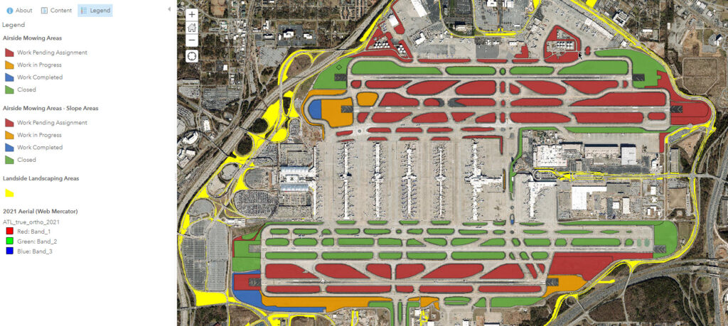
Real-Time Asset Intelligence
From the runway to the roadside, real-time data now powers maintenance decisions. Departments can monitor performance, track work orders, and complete inspections without paperwork or delays.
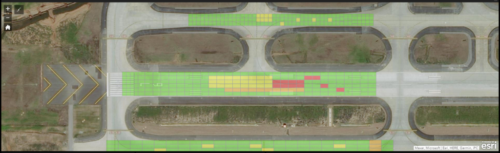
FAA Compliance, Reimagined
Once manual and error-prone, Part 139 inspections are now automated, documented, and geospatially visualized. What took days now takes minutes.
Cost Savings & Cloud Scalability
Migrating GIS infrastructure to AWS Linux not only optimized performance but unlocked long-term cost savings. Though the city is still quantifying these savings, early indicators are promising.
Centralized Data & Better Reporting
Information is now unified on one platform, improving the ability to report, analyze, and act. Decision-makers have better visibility and control across departments.
Customer Responsiveness
The integrated service request portal enables faster and more efficient responses to community needs.
Interdepartmental Expansion
The project’s success at HJAIA sparked broader interest. Cityworks is now being adopted by the Department of Transportation and Watershed, with more departments in the pipeline.
“Working with NV5, we modernized our GIS and asset management systems at HJAIA—automating FAA compliance, integrating real-time data, and moving to a scalable cloud platform that’s improving operations across departments.”
— David Wright, Airport Director, Geospatial Information Systems, Hartsfield-Jackson Atlanta International Airport
Before & After Snapshot
Capability | Before NV5 | After NV5 |
FAA Compliance | Manual, spreadsheet-based | Automated, geospatial, centralized in Cityworks |
Asset Management | Limited scalability with CMMS | Cityworks used across 10+ departments |
GIS Infrastructure | Windows, on-premises | AWS cloud-hosted, Linux-based |
Maintenance Tracking | Manual updates | Automated with Samsara + Cityworks integration |
Looking Ahead: The Future of GIS in Atlanta
The City of Atlanta isn’t stopping here. Automated Vehicle Location (AVL) integration is currently underway, and the Integrated Operations Center (IOC) will soon have real-time visibility into citywide assets. As more departments come online and GIS adoption deepens, NV5 continues to provide strategic guidance to ensure long-term sustainability.
Lessons Learned
- Start small, scale smart: Piloting the solution at HJAIA allowed departments to build confidence before full rollout.
- Train early and often: Adoption grew fastest where users were empowered with hands-on, department-specific training.
- Cloud is a long game: Transitioning to AWS + Linux required an upfront investment in skills but unlocked long-term efficiency.
Conclusion
With NV5’s help, the City of Atlanta transformed a legacy CMMS from a manual intensive process with a static GIS mapping interface into a dynamic platform for decision-making, compliance, and collaboration. Today, HJAIA runs more efficiently, and tomorrow, the rest of the city will too.
About NV5 Geospatial Airport Solutions
Many of the largest U.S. airports – including Minneapolis-St. Paul International, Hartsfield-Jackson Atlanta International, and Harry Reid International – and their partner firms rely on lidar, imagery, mapping data and enterprise GIS solutions from NV5 Geospatial. With the highest-quality NV5 Geospatial data as a foundation, these airports can build on their Esri-based enterprise GIS solution for FAA compliance, as well as develop or support specialized asset management tools to better manage, integrate and visualize data for better airport planning and maintenance.
The NV5 Geospatial Airport Solutions includes:
- Asset and environmental data acquisition – Lidar, thermal, imagery and hyperspectral sensors can be deployed via airborne, unmanned aerial vehicle, mobile and terrestrial platforms both inside and outside of a facility. The combination of these tools enables collection of engineering-grade data to support FAA reporting, including airport layout plans (ALPs), obstruction and vegetation surveys for mitigation and management, and indoor terminal mapping for facility management.
- Cloud migration and managed services – Confidence in the availability, scalability and performance of the technology infrastructure that underlies an enterprise GIS is central to successful implementation and adoption. Geospatial Cloud Services encompass assessments, design, implementation, migration and ongoing managed services. NV5 Geospatial provides the platform to support not only enterprise GIS, but complementary solutions for asset/work management (airside and landside), safety management, inspections, document management and more.
- Enterprise GIS systems and applications – One of only 17 global Platinum Partners of Esri and Cityworks, Axim Geospatial, a division of NV5 Geospatial, integrates data, as well as other business systems and applications, into a single dashboard available via desktop or mobile devices. The easy-to-use interface enables airport managers and their partners to visualize operational data – both indoors and out – to support informed, intelligent decision making.
- Modern digital twin applications – Data is delivered at an unprecedented level of detail, enabling development of an operational digital twin, or detailed representation of the physical environment, including interior, exterior, fixed and moveable assets. Using open data and APIs to power operational and management applications, digital twins can support a wide range of tasks, including property, utility and pavement management; noise monitoring; incident tracking; physical security and intrusion detection; and facilities, emergency, wildlife and concession management.
- Indoor digital twin and facility solutions – As an experienced, Esri Indoors software implementer, NV5 Geospatial can extend airport data acquisition to interior spaces with lidar, oriented/spherical imagery and infrastructure extraction, to support increasingly seamless routing, navigation, and next-generation experiences and facilities management. With expertise in building automation solutions, NV5 Geospatial can leverage indoor digital twins to drive energy efficiency and return on investments.
Our airport services also leverage industry partnerships, as well as our Esri Technical Certifications, that recognize our expertise in specific solutions. These include AWS Partner, Safe Software (FME), ArcGIS Cloud Services, ArcGIS System Ready, ArcGIS Indoors, ArcGIS Hub, Network Management, ArcGIS State and Local Government and ArcGIS Marketplace provider.
For more information about NV5 Geospatial’s Airport Solutions, please CLICK HERE to visit our webpage, or contact David Grigg at david.grigg@nv5.com or call 803.351.3136.
About NV5 Geospatial- NV5 Geospatial is a provider of geospatial services, providing end-to-end solutions and insights to organizations that need geospatial intelligence to mitigate risk, plan for growth, better manage resources and advance scientific understanding. We combine the widest array of advanced remote sensing technologies with proprietary processes, analytics tools, algorithms, and analyses tailored to meet our clients’ needs.