Use of robots equipped with sensors and cameras are helping to automate and improve maintenance of utilities.
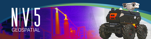
NV5 Geospatial, North America’s most comprehensive geospatial science data firm, today announced the debut of its ARIS II Rover. The upgraded robotic electric substation monitoring system comes after five years of in-field implementation and testing. The rover meets the industry’s most exacting standards for ruggedness and reliability, enabling it to function in harsh environmental conditions and over various terrains commonly found at distribution and transmission substations. The remotely controlled wheeled rover offers a modular design custom-fitted with advanced thermal sensors, imaging, and audio/video technology that allows utilities to protect assets and limit liability while speeding reaction time.
“Geographic and personnel limitations, combined with aging infrastructure, present significant challenges for utility companies when it comes to maintaining their substations,” said Ian Birdie, vice president of Innovation for NV5 Geospatial. “With our extensive experience in these substation environments, NV5 Geospatial has customized the ARIS II Rover for the unique needs of utilities. We built our next-generation robot on a rugged platform that can exist remotely and deliver the information and insights utilities need to maintain their networks proactively. On-time information allows quick response to equipment anomalies, weather events, and intrusions before they have an impact.”
The ARIS II rover supports a variety of applications, including event check-ups, situational awareness, health monitoring, work audits, inventory management, emergency response and security, offering:
- Industry-leading military standards (MIL-STD) and ingress protection ratings, resulting in a weatherproof design that can withstand and work reliably in harsh environments, and 36-degree climbing ability for difficult terrain.
- Pre-configured payload of sensors and equipment that supports thermal imaging, video and two-way audio communication capabilities, as well as GPS with real-time kinematics (RTK) that supports accurate mapping of drives within a substation.
- Modular design for flexibility in sensor and camera positioning and simplified maintenance on or off site, with the ability to carry up to 110 pounds of equipment.
- Up to six hours of battery life or two miles of driving and a recharge garage included when the rover is not in use.
- Easy installation and movement to different substation locations with a pallet-ready Rover and housing.
- Secure web portal that offers controls and management tools to support real-time inspection/driving, feedback and measurement from onboard sensors, and the ability to review and measure thermal conditions and high-resolution photos.
This combination of features enables the ARIS II Rover to assess conditions in substations. Thermal imaging captures temperature deltas against assets to help utilities determine when equipment needs to be evaluated and replaced. Onboard cameras can visually detect corrosion and asset damage, and are able to read gauges from up to 50 feet away.
To learn more about the ARIS II Rover or to schedule a demonstration, contact NV5G-Sales@nv5.com, or read more here.