Search
Archives

Our Latest Video Features More than Just Beauty Shots…

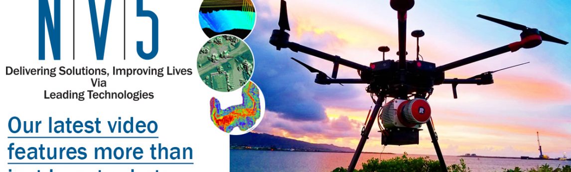
Images from drones, or Unmanned Aerial Vehicles are more than just beauty shots. Take a look at our new NV5 UAV one minute video.

Each UAV scan delivers the most accurate, multifaceted data for management success; from concept to construction. LiDAR point clouds map detailed landscaping, structures and power lines. Orthophoto Imagery base maps guide inspections and support construction with 3D Models that are indispensable. Thermal Imagery senses hotspots from water intrusion or overheating equipment in buildings. Topography images calculate volume in mines, lead environmental analysis and survey complex natural disasters. How else can you get this level of GPS-based detail? Good data drives good decisions, and our in-house fleet of UAVs and licensed NV5 pilots will gather YOUR data safer, faster and with the highest level of accuracy. We can deploy in just days to match the speed with which risk assessments and decisions are made, bringing you a multi-layered view of any surface to take your confidence and decision-making to greater heights!

Please fill out the form below for more information or to request a personal review of how NV5’s UAV team can gather more data faster and at a higher quality for your public sector or private agency projects.

Fill out the form below to download the handbook.

Form #1 - Redirection to PDF

Form #2 - Sends email containing the link to the PDF

"*" indicates required fields

This field is for validation purposes and should be left unchanged.

eNewsletter - NV5 Real Estate Transaction Services

Contact NV5 Real Estate Transaction Services

Download NV5 2022 Compliance Calendar

Please fill out the form below. After successful form submission, you will be redirected to the requested file. Thank you.

"*" indicates required fields

We are an equal opportunity employer. All applicants will be considered for employment without attention to race, color, religion, sex, sexual orientation, gender identity, national origin, veteran or disability status. We ensure nondiscrimination in all programs and activities in accordance with Title VI of the United States Civil Rights Act of 1964. If you need more information or special assistance for persons with disabilities or limited English proficiency, contact MaryJo OBrien at (954) 495-2112. Persons with hearing-and speech-impairments can contact the NV5 by using the Virginia Relay Service, a toll-free telecommunication device for the deaf (TDD). Call 711 for TTY/TDD.
This field is hidden when viewing the form
This field is for validation purposes and should be left unchanged.

Hyperspectral Imaging - Technically Speaking

Our internal innovation and development team constantly analyzes new technology and develops solutions to meet our client’s challenges. Our Technically Speaking series is one way we share our technical findings with the professional community. 

Please tell us a little about yourself by filling out the form below, and we’ll share the document with you, thanks!

Accuracy Part 1- Technically Speaking

Our internal innovation and development team constantly analyzes new technology and develops solutions to meet our client’s challenges. Our Technically Speaking series is one way we share our technical findings with the professional community. 

Please tell us a little about yourself by filling out the form below, and we’ll share the document with you, thanks!

Prune Optimization Webinar Recording

NV5 Geospatial releases a new predictive modeling platform for vegetation management that uses existing lidar and historical data to identify the relative level of asset risk from trees by quantifying the potential for causing asset damage. 

Please tell us a little about yourself by filling out the form below, and we’ll share the document with you, thanks!

Topobathy Lidar - Technically Speaking

Our internal innovation and development team constantly analyzes new technology and develops solutions to meet our client’s challenges. Our Technically Speaking series is one way we share our technical findings with the professional community. 

Please tell us a little about yourself by filling out the form below, and we’ll share the document with you, thanks!

Contact Geospatial

Contact Geospatial