Quantum Spatial to Present at International LiDAR Mapping Forum

Quantum Spatial, Inc. the nation’s largest independent geospatial data firm, will showcase its leadership in use of next-generation sensors to support wide-area programs, such as the U.S. Geological Survey (USGS) 3D Elevation Program (3DEP), topographic-bathymetric (topo-bathy) LiDAR and unmanned aerial vehicles (UAVs) at the International LiDAR Mapping Forum (ILMF) next week. The company’s geospatial professionals will take part in numerous presentations and panel discussions, and will be available for focused discussions and demonstrations in the Quantum Spatial booth.

Visit our experts in Denver Feb 13 – Feb 15 at booth #46 to learn more about how Quantum Spatial can support your geospatial mapping needs.

Quantum Spatial’s Russell Faux, senior vice president will deliver these presentations:

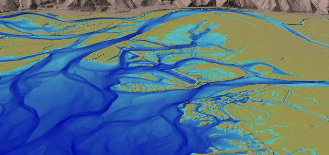
  • Performance of the Riegl VQ-880-G LiDAR Sensor in Mapping Coastal Near-Shore Bathymetry – February 15, 9:10 a.m. – Faux will explain how topographic-bathymetric (topo-bathy) LiDAR continues to develop as a unique tool for mapping near-shore and intertidal zones. He will highlight a case study of how Quantum Spatial is deploying the Riegl VQ-880-G – a next-generation topo-bathy LiDAR sensor – to map more than 200 miles of South Carolina coastline for National Oceanic and Atmospheric Administration’s (NOAA) National Geodetic Survey. Faux also will share results of the sensor’s performance in capturing detailed elevation data in coastal near-shore and estuarine environments, as well as lessons learned from deploying the Riegl VQ-880-G for this and similar mapping projects.
  • Utilizing UAV-based LiDAR and Imagery Technology for Coastal and Wetland Applications – February 15, 3:10 p.m. – Faux will join with Matthew Coleman from PrecisionHawk to discuss how Quantum Spatial acquires, processes and delivers high-resolution aerial LiDAR data and multispectral imagery from unmanned aerial systems (UAS) for the NOAA Office for Coastal Management (OCM). They will demonstrate the benefits and difficulties of working with unmanned aerial vehicle (UAV)-based LiDAR for mapping-grade projects. The presentation will address data acquisition using PrecisionHawk’s Lancaster 5 fixed-wing aircraft and In-Flight software for flight planning and management during acquisition, along with automated and semi-automated data processing.

Faux also will participate in panel discussions:

  • UAVs – February 15, 3:30 p.m. – Faux, with speakers from Aerial Services, Cognizant and PrecisionHawk, will provide further insight into the practical applications of UAS technologies (e.g., UAS-based LiDAR) with respect to traditional mapping requirements and project considerations.

For more information, or to set up a meeting at the Quantum Spatial booth, email Michael Shillenn at mshillenn@quantumspatial.com.

We look forward to seeing you in Denver!

Sincerely,

The Quantum Spatial Team 
contact@quantumspatial.com

1-800-558-6707

Fill out the form below to download the handbook.

Form #1 - Redirection to PDF

Form #2 - Sends email containing the link to the PDF

"*" indicates required fields

This field is for validation purposes and should be left unchanged.

eNewsletter - NV5 Real Estate Transaction Services

Contact NV5 Real Estate Transaction Services

Download NV5 2022 Compliance Calendar

Please fill out the form below. After successful form submission, you will be redirected to the requested file. Thank you.

"*" indicates required fields

We are an equal opportunity employer. All applicants will be considered for employment without attention to race, color, religion, sex, sexual orientation, gender identity, national origin, veteran or disability status. We ensure nondiscrimination in all programs and activities in accordance with Title VI of the United States Civil Rights Act of 1964. If you need more information or special assistance for persons with disabilities or limited English proficiency, contact MaryJo OBrien at (954) 495-2112. Persons with hearing-and speech-impairments can contact the NV5 by using the Virginia Relay Service, a toll-free telecommunication device for the deaf (TDD). Call 711 for TTY/TDD.
This field is hidden when viewing the form
This field is for validation purposes and should be left unchanged.

Hyperspectral Imaging - Technically Speaking

Our internal innovation and development team constantly analyzes new technology and develops solutions to meet our client’s challenges. Our Technically Speaking series is one way we share our technical findings with the professional community. 

Please tell us a little about yourself by filling out the form below, and we’ll share the document with you, thanks!

Accuracy Part 1- Technically Speaking

Our internal innovation and development team constantly analyzes new technology and develops solutions to meet our client’s challenges. Our Technically Speaking series is one way we share our technical findings with the professional community. 

Please tell us a little about yourself by filling out the form below, and we’ll share the document with you, thanks!

Prune Optimization Webinar Recording

NV5 Geospatial releases a new predictive modeling platform for vegetation management that uses existing lidar and historical data to identify the relative level of asset risk from trees by quantifying the potential for causing asset damage. 

Please tell us a little about yourself by filling out the form below, and we’ll share the document with you, thanks!

Topobathy Lidar - Technically Speaking

Our internal innovation and development team constantly analyzes new technology and develops solutions to meet our client’s challenges. Our Technically Speaking series is one way we share our technical findings with the professional community. 

Please tell us a little about yourself by filling out the form below, and we’ll share the document with you, thanks!

Contact Geospatial

Contact Geospatial