Revitalizing America’s Infrastructure via 3DEP

The American landscape changes constantly. Rapid land development and environmental forces make outdated elevation data irrelevant for current analysis. Advances in technology have exposed inaccuracies in older data, making it a poor resource for critical future planning.
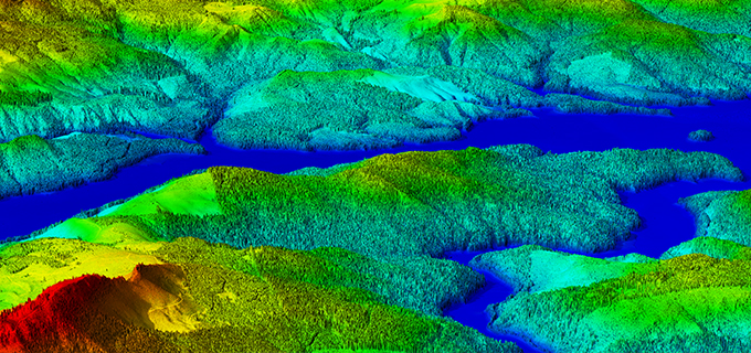
That’s why the US Geological Survey is revolutionizing the country’s understanding of its terrain with the 3D Elevation Program, or 3DEP. USGS brings together government partners with LiDAR mapping technology leaders like Quantum Spatial. 3DEP provides federal, state, local, and private sector organizations with the accurate data they need to address climate change risks, plan emergency response, mitigate flooding, secure infrastructure, manage natural resources, and improve agricultural productivity at a price everyone can afford.

A fully funded and implemented 3DEP would provide more than $690 million annually in benefits to government entities, the private sector, and citizens, resulting in a nearly 5:1 return on investment.

In the latest issue of LiDAR magazine, USGS’ Vicki Lukas describes how 3DEP aids infrastructure and construction managment by providing valuable planning intelligence such as:

⦁ Terrain and other obstruction identification for aviation

⦁ Dam, levee, and coastal-structure failure modeling and mitigation

⦁ Hydraulic and hydrologic modeling

⦁ Evaluations of geologic, coastal, and other natural hazards, and geotechnical evaluations

⦁ Permit application and construction plan development and evaluation

⦁ Drainage issues and cut-and-fill estimate requirements

⦁ Vegetation, topographic, and geomorphologic feature analysis

⦁ As-built model development

⦁ Preliminary engineering, estimate development, and quantity estimation activities

⦁ Base-map and elevation model creation

CLICK HERE to read the full LiDAR Magazine article.

Fill out the form below to download the handbook.

Form #1 - Redirection to PDF

Form #2 - Sends email containing the link to the PDF

"*" indicates required fields

This field is for validation purposes and should be left unchanged.

eNewsletter - NV5 Real Estate Transaction Services

Contact NV5 Real Estate Transaction Services

Download NV5 2022 Compliance Calendar

Please fill out the form below. After successful form submission, you will be redirected to the requested file. Thank you.

"*" indicates required fields

We are an equal opportunity employer. All applicants will be considered for employment without attention to race, color, religion, sex, sexual orientation, gender identity, national origin, veteran or disability status. We ensure nondiscrimination in all programs and activities in accordance with Title VI of the United States Civil Rights Act of 1964. If you need more information or special assistance for persons with disabilities or limited English proficiency, contact MaryJo OBrien at (954) 495-2112. Persons with hearing-and speech-impairments can contact the NV5 by using the Virginia Relay Service, a toll-free telecommunication device for the deaf (TDD). Call 711 for TTY/TDD.
This field is hidden when viewing the form
This field is for validation purposes and should be left unchanged.

Hyperspectral Imaging - Technically Speaking

Our internal innovation and development team constantly analyzes new technology and develops solutions to meet our client’s challenges. Our Technically Speaking series is one way we share our technical findings with the professional community. 

Please tell us a little about yourself by filling out the form below, and we’ll share the document with you, thanks!

Accuracy Part 1- Technically Speaking

Our internal innovation and development team constantly analyzes new technology and develops solutions to meet our client’s challenges. Our Technically Speaking series is one way we share our technical findings with the professional community. 

Please tell us a little about yourself by filling out the form below, and we’ll share the document with you, thanks!

Prune Optimization Webinar Recording

NV5 Geospatial releases a new predictive modeling platform for vegetation management that uses existing lidar and historical data to identify the relative level of asset risk from trees by quantifying the potential for causing asset damage. 

Please tell us a little about yourself by filling out the form below, and we’ll share the document with you, thanks!

Topobathy Lidar - Technically Speaking

Our internal innovation and development team constantly analyzes new technology and develops solutions to meet our client’s challenges. Our Technically Speaking series is one way we share our technical findings with the professional community. 

Please tell us a little about yourself by filling out the form below, and we’ll share the document with you, thanks!

Contact Geospatial

Contact Geospatial