By Michael Parma, Senior Solutions Architect, NV5
The clock is ticking on Esri’s Geometric Network (GN), and for utilities still relying on it there are some serious decisions to be made. With ArcMap officially retired and support for GN ending in March 2026, utilities need to take a look at how they’re using the data, what they want to get out of it, and the type of technology needed to achieve their goals.
Already, there’s been a foundational shift as Esri has moved to its ArcGIS Utility Network (UN), a modern, service-based architecture built for scale, security, and smart integration. This wasn’t just a software upgrade. It was a strategic pivot from legacy desktop tools to a future-ready platform that supports real-time data, mobile workflows, and advanced analytics.
If you haven’t started planning your transition, now’s the time.
The Risks Ahead
GN may still “work,” but it’s running on borrowed time. Without ongoing support, there are numerous risks you must weigh:
- Cybersecurity vulnerabilities from an unsupported architecture
- Incompatibility with modern workflows, mobile apps, and IoT integration
- Reduced functionality and limited editing capabilities
- Operational inefficiencies from disconnected field-to-office processes
ArcGIS Pro and UN offer a significant upgrade. Think of it as moving from a flip phone, which allows you to make calls but is unwieldy for texting and incapable of surfing the net, to a smartphone – a more powerful platform that puts information and analysis in the palm of your hand. UN supports:
- Real-time data integration, connecting the field and office
- Enhanced network tracing
- Validated connectivity and topological accuracy
- Scalable performance for large datasets
Making the Transition: Strategic Steps for Successful Implementation
Whether you’re a large utility or a smaller municipal agency, the transition path isn’t one-size-fits-all. Here’s how to approach it:
Assess Data Readiness – Start with a data audit. Clean, structured data is essential for a smooth migration. If you don’t already have clean data, NV5 can help with data acquisition.
Evaluate Business Needs – Do you need advanced tracing and analytics or is asset visualization sufficient? Your use case(s) will shape your migration strategy.
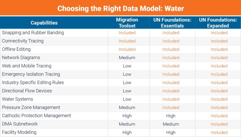
Choose Your Migration Path – Esri now offers multiple options that meet a range of needs:
- Expanded Model: Comprehensive but complex –ideal for large utilities with needs for robust functionality.
- Essentials Model: A leaner, more accessible model for faster adoption.
- Migration Toolset: Converts GN data to UN format without full model adoption – perfect for smaller utilities under a time crunch.
Plan for Integration – Consider how UN will interact with asset management systems, billing platforms, hydraulic models, and CCTV workflows.
Set Realistic Timelines – Water systems can make the transition in three months to a year, depending on the model selected, while it may take electrical utilities more than two years. For smaller utilities and municipal systems, transitions can take just a few weeks with the migration toolset.
Evaluate Support Needs – Determine if your team can manage the transition in-house or if you will need a partner with deep domain expertise.
What to Look for in a Transition Partner: The NV5 Advantage
If you’re looking for support in the transition, it’s important to remember that not all partners are created equal.
Here at NV5, we bring a unique set of skills and experience that will ease your transition:
- Double Platinum Partner – Esri and Trimble
- First to earn Esri’s network management specialty based on experience with water
- Large, dedicated team focusing solely on UN work
Proven track record with planning support of more than 100 different systems for 50+ clients, such as Boston Water and Sewer Commission, Charlotte Water, and City of Mercer Island, Wash.
We aren’t just a vendor – we consider ourselves your strategic ally. We’ve been working on GN-to-UN transitions for nearly a decade, supporting large utility clients and smaller agencies alike. Whether you’re just starting or racing against the clock to transition from GN, NV5 can help.
If you want to learn more, join me, my colleague Chris Mousetis and Esri’s Matt Kennedy on Wednesday, September 24, at Noon ET for our webinar, Navigating the ArcGIS Utility Network Journey: Planning, Progress, and What’s Next. You can register here for this free event.
Hi there, join us for this upcoming webinar!
Wednesday, September 24
Noon ET / 11am CT
With Esri’s geometric network retiring in March 2026, water utilities are moving fast. This practical session shows how to plan your ArcGIS Utility Network (UN) migration—and, more importantly, how to drive operational value after go-live.