
NV5 Acquires Geodynamics, Expanding Deep-Water Geospatial Capabilities
HOLLYWOOD, Fla., March 29, 2021 (GLOBE NEWSWIRE) — NV5 Global, Inc. (the “Company” or “NV5”) (Nasdaq: NVEE), a provider of compliance, technology, and engineering consulting
HOLLYWOOD, Fla., March 29, 2021 (GLOBE NEWSWIRE) — NV5 Global, Inc. (the “Company” or “NV5”) (Nasdaq: NVEE), a provider of compliance, technology, and engineering consulting

Registration is open for the Alaska Virtual Geospatial Gathering March 1st – 4th. We have over two dozen speakers lined up to cover geospatial topics
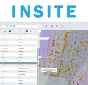
INSITE Manage | Visualize | Integrate INSITE provides on-demand access to cloud-hosted GIS and map data, 3D models, and analytics dashboards. Web-based architecture makes INSITE a
NV5 Global, Inc. (the “Company” or “NV5”) (Nasdaq: NVEE), a provider of compliance, technology, and engineering consulting solutions, announced today that NV5 Geospatial, formerly Quantum Spatial,
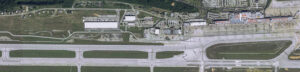
Bob Vander Meer, vice president of business development for NV5 Geospatial (Powered by Quantum Spatial), discusses NV5 Geospatial’s work with Airports on the Airplane Geeks Podcast. Bob has over
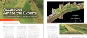
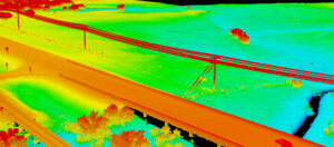
Lidar technology continues to advance, both in terms of sensor hardware and platform deployment. NV5 Geospatial and Oklahoma Department of Transportation performed a series of tests

Zpryme On The Grid · Changing Responses to Changing Disasters w/ Ian Berdie Zpryme’s Dylan Lockwood speaks with Ian Berdie, Vice President of Innovation
NV5 Geospatial, powered by Quantum Spatial, North America’s largest geospatial data firm, has dramatically expanded its Canadian operations in 2020, having been selected to provide lidar,
Keeping transportation projects on time and on budget can be a challenge for numerous reasons. But inaccurate mapping shouldn’t be one of them. NV5 Geospatial’s
HOLLYWOOD, FLA. (PRWEB) OCTOBER 21, 2020 Quantum Spatial, Inc., an NV5 company and North America’s largest geospatial data firm, recently completed the collection of topographic and