Fusing Data on Doomed Ash Trees
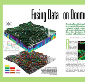
The emerald ash borer is decimating the ash trees across the nation, leading to large quantities of unhealthy and dead trees. In the presence of
The emerald ash borer is decimating the ash trees across the nation, leading to large quantities of unhealthy and dead trees. In the presence of
Leading from a distance: Jeffery Skahill, Software Development Manager at Quantum Spatial, shares his tips for leading teams working remotely amid the pandemic challenges with
NV5 announces contract with NOAA’s National Geodetic Survey division. Read full release HERE.

Ron Chappel, founder and CEO of GEO1, has distinguished himself as a leader in aerial remote sensing acquisition. In the latest issue of Lidar Magazine, Jeff Winke
In celebration of National Surveyors Week, we’re spotlighting our dedicated surveyors! If you are interested in employment opportunities check out our openings HERE. Or, get in

To our Quantum Spatial Clients & Partners, As we together face the challenge of the COVID-19 global pandemic, I wanted to reach out to update
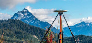
Linda Duffy, in the latest issue of Point of Beginning, delves deep into the advancements in satellite positioning systems, specifically how they have aided in geospatial
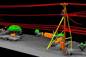
Quantum Spatial, an NV5 company and North America’s largest geospatial data firm, today announced a pole clearance and loading analytics solution that will enable electric
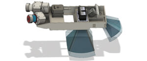
Quantum Spatial, Inc., an NV5 company, and the nation’s largest independent geospatial data firm, today announced its new sensor platform, which is designed to improve

Hollywood, FL – January 20, 2020 – NV5 Global, Inc. (the “Company” or “NV5”) (Nasdaq: NVEE), a provider of professional and technical engineering and consulting solutions,