
Learn about surveyor life from Scott, one of Quantum Spatial’s dedicated professionals
In celebration of National Surveyors Week, we’re spotlighting some of our dedicated surveyors and sharing their insights of a survey career. If you are interested
In celebration of National Surveyors Week, we’re spotlighting some of our dedicated surveyors and sharing their insights of a survey career. If you are interested

In celebration of National Surveyors Week, we’re spotlighting some of our dedicated surveyors and sharing their insights of a survey career. If you are interested

As Quantum Spatial’s eGIS Practice Lead, Cherie Jarvis has managed Agile development teams comprised of team members lively all across the Unitied States. In SD Times, she

Hosted by DM radio, Quantum Spatial’s Anand Iyer participates in a panel discussion about companies that harness big data to provide solutions to wide-ranging real-world challenges.

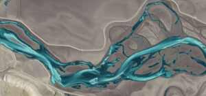
The new year is here, have a downloadable desktop calendar that showcases an amazing view of Kipnuk, Alaska. There are two different image sizes to accommodate variation
ST. PETERSBURG, Fla., Jan. 29, 2019 (GLOBE NEWSWIRE) — Quantum Spatial, Inc. (QSI), the nation’s largest independent geospatial data firm, this week was presented with two MAPPS

Quantum Spatial (QSI), the nation’s largest independent geospatial analytics firm, will showcase its cutting-edge applications for surveying and mapping, using high-resolution topographic and bathymetric LiDAR
Jim DePasquale, of the Nature Conservancy, shares his experiences of using LiDAR mapping technology in Alaska through the use of USGS’ 3D Elevation Program in Directions Magazine.

Once again, Ms. Caroline Coholan’s 3rd grade class from Llewellyn Elementary School visited Quantum Spatial’s Portland office to celebrate National GIS day. Following an engaging presentation on

As the pace of innovation continues at a breakneck pace throughout the remote sensing industry, new applications for spatial data are emerging. Quantum Spatial’s Anand