
We’re at Coastal GeoTools 2017!
Quantum Spatial, Inc. the nation’s largest independent geospatial data firm, will showcase its industry-leading use of topographic-bathymetric (topo-bathy) LiDAR and advanced analytics to support natural
Quantum Spatial, Inc. the nation’s largest independent geospatial data firm, will showcase its industry-leading use of topographic-bathymetric (topo-bathy) LiDAR and advanced analytics to support natural
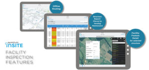
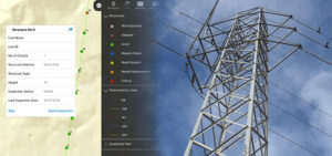
What if you could answer questions and tackle changes in your distribution system before they become problems? Distribution Network Intelligence builds foundationally on geospatial analytics

For the second year in a row, the Portland, Oregon office of Quantum Spatial held a food drive to support the Oregon Food Bank. The

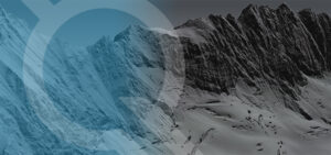
The new year is right around the corner, and we have a downloadable desktop calendar that showcases an amazing view of Chandler Lake, Alaska. There are
Quantum Spatial’s Scott Nowicki was recently published in Directions Magazine discussing the current and future state of drones. The article explores optimal uses for drone
The Digital Coast Act (Authorization bill) passed the full senate on Nov 28. If the bill passes the house and becomes law, it will authorize

NORCROSS, GA – November 28, 2016 – Quantum Spatial, Inc., the nation’s largest independent geospatial data firm, today announced that its principal R&D scientist Scott
Quantum Spatial is attending the Alaska Miners Association conference, Novemember 8-10, at the Dena’ina Civic and Convention Center in Anchorage. Our Alaska-based team is expert at

During November 1 Session, Matt Boyd Will Detail How to Use Spatial Analytics to Manage Risk, Reliability and Compliance Quantum Spatial, Inc., the nation’s largest independent geospatial
I’m excited to attend the upcoming CEATI transmission conference, and I look forward to working toward helping asset management programs improve safety, reliability, and efficiency.