
Aerial MOB and Quantum Spatial Announce Strategic Alliance
Aerial MOB, LLC, a leader in UAS (drone) aerial technology applications, has reached a strategic partnership agreement with Quantum Spatial Inc. (QSI), a leading supplier
Aerial MOB, LLC, a leader in UAS (drone) aerial technology applications, has reached a strategic partnership agreement with Quantum Spatial Inc. (QSI), a leading supplier

We’d like to share one of our favorite traditions – a stunning aerial photo for your computer as a desktop wallpaper. About This Image Denali
Quantum Spatial is pleased to announce that the company will serve as a bronze sponsor to LASzip in LiDAR. As a sponsor, we will contribute

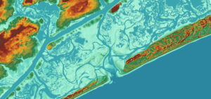
Quantum Spatial is currently mapping Glacier Peak for the U.S. Geological Survey’s 3DEP program and was featured in a news story from KIRO 7 in
The NOAA Sandy Supplemental Sandy Topobathy LiDAR and Imagery project was recognized has been recognized with the LCDR Peter Johnson Best Practices Award at the

Quantum Spatial is hiring geospatial professionals for both short-term and long-term opportunities. We are looking for talented individuals to join both our office and field

The U.S. Navy has awarded NAVGeo LLC a $30 million contract to provide geographic information systems, surveying and mapping services. NAVGeo is a joint venture

Quantum Spatial is pleased to announce the opening of our new office in Novato, CA, which will continue the sale of historical photo archives of
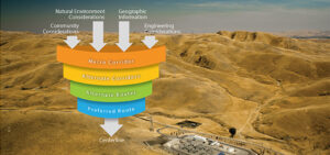
When siting a transmission line, electric utilities must consider many factors, including protecting the natural environment, effects on the community, engineering challenges, cost efficiency, and

All you need is a photograph? Quantum Spatial has that, and much more! Quantum Spatial owns a rich historical archive of aerial imagery. Our photo collection dates