Geospatial Software Solutions
Geospatial Software Solutions Answers you can trust. eGIS Software Solutions Answers you can trust. Design. Manage. Analyze. Answer. NV5 Geospatial offers a comprehensive selection
Geospatial Software Solutions Answers you can trust. eGIS Software Solutions Answers you can trust. Design. Manage. Analyze. Answer. NV5 Geospatial offers a comprehensive selection

NV5 earned the Excellence Award in Surveying/Field Data Collection, announced at the 2023 MAPPS Winter Conference Overview- One of only six hypersaline lagoons in the
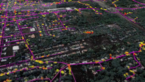
Asset and Vegetation Management Applications Help Utilities Minimize Risk and Improve Reliability of Electric Utilities NV5 Geospatial Uses Remote Sensing for UtilitiesGeospatial data firm NV5
HOLLYWOOD, Fla., Feb. 16, 2023 (GLOBE NEWSWIRE) — NV5 Global, Inc. (the “Company” or “NV5”) (Nasdaq: NVEE), a provider of technology, conformity assessment, and consulting

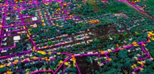
Electric utilities are pivotal in providing electricity to residences and businesses in the U.S. However, the emerging labor shortage, rising energy consumption, and uncontrollable weather
NV5 Awarded $9 Million NOAA Contract to Support Shoreline Mapping in Maine November 22, 2022 HOLLYWOOD, Fla., Nov. 22, 2022 (GLOBE NEWSWIRE) — NV5 Global,

NV5 Geospatial’s Ian Berdie was recently a guest on the Data Management Podcast to discuss the practicality and use of geospatial engineering and lidar. To
Asset and Vegetation Management Applications Help Utilities Minimize Risk and Improve Reliability of Electric Distribution Network HOLLYWOOD, Fla., October 11, 2022 – NV5 Geospatial, North America’s most

We extend our heartfelt congratulations to our very own Tim Saultz, who was awarded The Distinguished Service Award, the highest honorary recognition an employee can

Written by Joel Burroughs, NV5 Geospatial Account Manager When volcanoes erupt, the force of explosions and lava dramatically change the landscape, impacting the geography and